UTAH/COLORADO
ROAD TRIP
June–July, 2007
BIG
PICTURE
Some would say we had a date to do volunteer work at
Best Friends Animal Sanctuary in Kanab, Utah and we found and visited
interesting places both going and coming. Some would say that we are
masochists looking
to experience extreme summer heat—and what better place to go than to
southern Utah? Others might think we wanted to test our compatibility
by living
in a 19’x7’ space with two dogs for four weeks. As it turned out, all
are true and we returned to tell the tale.
STATE AND
NATIONAL PARKS
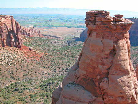
•Colorado
National
Monument. The evening we left Nederland we camped at Colorado
National Monument on the western edge of the state just off I-70.
This under-used park features massive sandstone
formations that surround a steep-walled canyon. We found excellent
hiking and a very
scenic (and recently repaved) road for bicycling.
We entered the monument from the east
side through
Grand Junction. As a result, we drove the 23-mile Rim Rock Drive
that leads to Saddlehorn Campground, which is on the other side of the
park just inside the west
entrance. The drive is spectacular for the views down into and across
the canyon and out to the valley of the Colorado River.
If we had worried about getting a
camping site for
the two nights we’d planned to be there, we needn’t have worried. Few
of the sites were taken and by the next morning fewer than half the 80
sites were taken. There are no
facilities, except for water faucets and flush toilets, and no
reservations are taken. We wedged the RV among some pinon trees and
did our best to level the vehicle. We walked the dogs to an overlook
area in the campground, took some photos, returned for cocktails,
dinner, some gin rummy (we kept a running score for the entire
trip), and TV(!).
We turned on the TV in the morning to
get the
weather and within a couple of 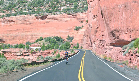 minutes, the picture and sound
quit. We
decided either the TV died or the two “house” batteries (the ones in
the living area, not for the engine) were too weak.
A call to
Winnebago directed us to an RV dealer in Grand Junction to check what
needed help, the batteries or the TV. Our appointment was for the late
afternoon. So, after breakfast, Judy went for a morning run while
Hughes
made some more calls. When she got back, we rode our bikes out on the
Rim Rock Road, a fairly level ride along the canyon
rim. We stopped at several trail heads that led us down
into the
valley. By 11:00 a.m. the sun turned up the heat: we had biked only
about five miles, but we turned around at Artist Point planning to ride
the rest
of the the road the next day.
minutes, the picture and sound
quit. We
decided either the TV died or the two “house” batteries (the ones in
the living area, not for the engine) were too weak.
A call to
Winnebago directed us to an RV dealer in Grand Junction to check what
needed help, the batteries or the TV. Our appointment was for the late
afternoon. So, after breakfast, Judy went for a morning run while
Hughes
made some more calls. When she got back, we rode our bikes out on the
Rim Rock Road, a fairly level ride along the canyon
rim. We stopped at several trail heads that led us down
into the
valley. By 11:00 a.m. the sun turned up the heat: we had biked only
about five miles, but we turned around at Artist Point planning to ride
the rest
of the the road the next day.
That afternoon we went into Grand
Junction to
Humphry’s RV and Trailer. After a quick inspection,
we were told that
the TV was probably a goner and the
batteries were weak but could be charged by driving 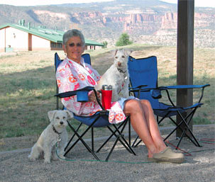 (which
we’d been
doing) and by plugging the unit into
electricity for a couple of days.
(which
we’d been
doing) and by plugging the unit into
electricity for a couple of days.
• James M
Robb-Colorado River State Park. We paid Humphry’s for the
information and decided we’d better plug in and start charging the
batteries. So, we spent the night at the Colorado
River State Park on the
south side of nearby Fruita.
At the Fruita
campground we had great views, a level site, showers, lots of shade, a
dump station, and water and electric hook-ups. It’s a lovely state park
with a swimming area, fishing, access to the Colorado River, and very
clean facilities. The cost with a season pass was a bargain at $9! We
certainly needed the electricity, not only to charge the batteries but
to run the much needed air conditioner. We biked into town for pizza,
logged on to some free wi-fi to check email, and lounged on the
courthouse lawn for a free bluegrass concert as the sun was setting. In
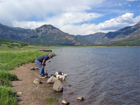
the morning, Judy ran along the Colorado after breakfast while Hughes
got us ready to be on our way. (He took this photo of Judy and the dogs
after her post-run shower.)
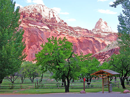 •Capitol Reef
National Park. After leaving Fruita (Colorado), we spent a
night in Green
River, Utah at Shady Acres
RV Park, advertised as “The Cleanest RV park
in Green River.” As we were driving the 100 miles along I-70, we tried
to remember what Green River was like, and what we might see or do
while we were there in the afternoon/evening. What we’d forgotten was
what a sad looking and forlorn town it is! We knew we had stopped there
in the past for the
delicious melons that grow in the area; we had
visited the John Wesley Powell River
History Museum; and we’d probably
eaten a meal there. But this was some years ago. What we saw on this
trip was a dying town, with gas stations on either end of the business
loop off the interstate and a scattering of motels (some of which have
lost their dignity along with their coat of paint and smooth parking
area). A sure sign of the town’s demise is that the once proud stone
bank building on the central corner in “downtown” Green River now
houses a T-shirt store. Very sad! It would be tough to tell others you
were from Green River. However, Shady Acres had electricity, so we
charged the batteries, ran the A/C, and stayed indoors to avoid the
100° temperatures.
•Capitol Reef
National Park. After leaving Fruita (Colorado), we spent a
night in Green
River, Utah at Shady Acres
RV Park, advertised as “The Cleanest RV park
in Green River.” As we were driving the 100 miles along I-70, we tried
to remember what Green River was like, and what we might see or do
while we were there in the afternoon/evening. What we’d forgotten was
what a sad looking and forlorn town it is! We knew we had stopped there
in the past for the
delicious melons that grow in the area; we had
visited the John Wesley Powell River
History Museum; and we’d probably
eaten a meal there. But this was some years ago. What we saw on this
trip was a dying town, with gas stations on either end of the business
loop off the interstate and a scattering of motels (some of which have
lost their dignity along with their coat of paint and smooth parking
area). A sure sign of the town’s demise is that the once proud stone
bank building on the central corner in “downtown” Green River now
houses a T-shirt store. Very sad! It would be tough to tell others you
were from Green River. However, Shady Acres had electricity, so we
charged the batteries, ran the A/C, and stayed indoors to avoid the
100° temperatures.
The next day we drove south to
Hanksville and east
through the eerie desolation of Utah’s central moonscape that seems
devoid of any life except where cottonwoods, tamarisk, and willows
announce the presence
of water. Among the steep sandstone canyons formed by the
Fremont River are the remains of the town of Fruita, a welcome
oasis of
orchards and farms established by Mormon settlers in the late 19th
century, now abandoned and part of Capital
Reef National Park. The
 Fremont
creates a narrow ribbon of green in this otherwise dry,
isolated area, a lifeline for those who lived along its banks. The
Fremont Culture
thrived here as early as 700 C.E. alongside the Anasazi
who lived to the south. Like the Anasazi, the Fremont people
disappeared about 1300 C.E. leaving their pictographs (painted images)
and petroglyphs (chipped/scraped images) on many canyon walls.
Fremont
creates a narrow ribbon of green in this otherwise dry,
isolated area, a lifeline for those who lived along its banks. The
Fremont Culture
thrived here as early as 700 C.E. alongside the Anasazi
who lived to the south. Like the Anasazi, the Fremont people
disappeared about 1300 C.E. leaving their pictographs (painted images)
and petroglyphs (chipped/scraped images) on many canyon walls.
Mormon settlers
planted fruit trees—apricots, cherries, apples, pears, and
peaches—that can still be seen and their fruit eaten by visitors. In
addition, they raised cows and kids. When they moved away in the late
1930s, they left behind log houses, their school, and other buildings
scattered in the valley, all of which can be visited.
The Fremont River continues to attract
a wide
variety of animals: mule deer are a common sight in the campground
area, as are a wide variety of birds and the occasional mosquito.
Cottonwoods, ash, and other mature trees provide a thick canopy
of shade that made staying there very comfortable, even on the warmest
days of summer. We had no qualms about leaving Sophie and Bella in the
RV for a few hours each day while we hiked or biked. They knew it was
hot: they slept, drank a lot of water, panted a good deal, and were not
 very much interested in what was going on around them. Our
campsite was
just a few yards from the river and
we spent the hottest parts of the day soaking in the cool
water. We brought Sophie and Bella down to cool off and to rinse some
of the road dust out of their coats.
very much interested in what was going on around them. Our
campsite was
just a few yards from the river and
we spent the hottest parts of the day soaking in the cool
water. We brought Sophie and Bella down to cool off and to rinse some
of the road dust out of their coats.
We spent our first full day in the park
biking south
to the end of the pavement along the Waterpocket Fold, an uplift of
rock layers that, along with the forces of erosion, created spectacular
cliffs, domes, spires, arches, and twisting canyons for 100 miles
across the middle of the state. We watched for
jackrabbits, Gamble’s quail, and other signs of life, though the
farther from the river you go the less animal life there is. When the
pavement
ended after ten miles, we rode east on a dirt road down Capitol Gorge,
which was, amazingly, the
route of the original road through this region of the state. But the
narrow roadway often flooded and often filled with boulders and rubble,
and was abandoned when the current State Highway 24 was
completed in 1962.
When the dirt road ended, we hiked
another few
miles through the gorge where we could see the signatures of 19th
century explorers who left their marks in the red sandstone. We
searched
out “bowls” scoured out in the rocks where rainwater collects to quench
the thirst
of animals and humans who know where to look. The heat was building and
we shortened our hike because of it. On the way back, Judy’s rear tire
exploded! Both the tube and tire weakened in the heat and gave
way suddenly to a rock in the road 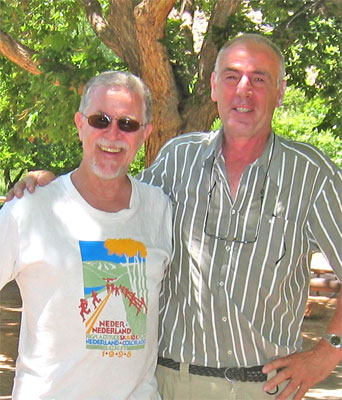 nearly 12 miles from camp.
Fortunately, some
folks in a pickup were going her way and took her and the bike back to
the
campground, while Hughes continued on alone. He met and talked with
a couple from the Netherlands, Marinus and Hanneke Verhulst, who were
touring the west. They were not planning to go through Denver, and
therefore would miss Nederland, so they stopped by the campground on
their way out. Hughes gave them the Nederland T-shirt right off his
back as a
souvenir.
nearly 12 miles from camp.
Fortunately, some
folks in a pickup were going her way and took her and the bike back to
the
campground, while Hughes continued on alone. He met and talked with
a couple from the Netherlands, Marinus and Hanneke Verhulst, who were
touring the west. They were not planning to go through Denver, and
therefore would miss Nederland, so they stopped by the campground on
their way out. Hughes gave them the Nederland T-shirt right off his
back as a
souvenir.
We spent the afternoon chilling out in
the river,
reading, and relaxing. We knew we’d have to get a new tire for Judy’s
bike, but not anywhere close by. We were due at Kodachrome
Basin
State Park in two days. However, we liked Capital Reef:
Judy
could run, we could hike, and we
could drive the RV anywhere on pavement. That evening we attended a
ranger
campfire program on the history of the Fremont Culture in this area,
and then slept comfortably in the cool night air.
In the morning, we discovered the
battery charge
indicator on the systems panel showed we had virtually no power from
the batteries, the same
batteries that were supposed to be charged by driving and by plugging
in to outside power. So, while Judy
ran, Hughes biked to the Visitors Center and called Winnebago and
Interstate Batteries. Everyone on the phone was quite pleasant
(Is this
because “this call will be monitored for quality control?”), especially
Annie at Interstate who eventually 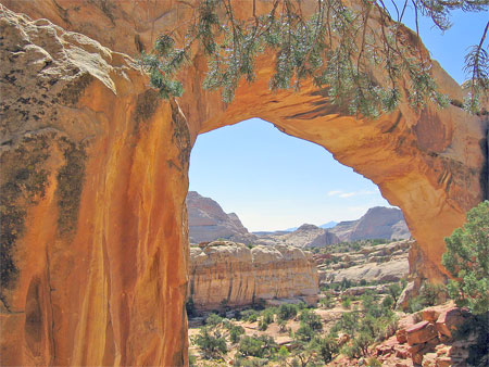 found a dealer in Richfield (90
miles west) who had two in stock and they would swap them out for new
ones. No charge under warranty. We just had to go out of our way to get
to Richfield.
found a dealer in Richfield (90
miles west) who had two in stock and they would swap them out for new
ones. No charge under warranty. We just had to go out of our way to get
to Richfield.
We used the rest of the morning to pack
and drive to
the trail head for a last hike in Capitol Reef: a short hike to a
natural arch named Hickman’s Bridge. Two hours later we drove through
Torrey and Loa to Richfield and pulled into Jorgensen’s
mid-afternoon for what we
thought would be a quick swap-out.
Jorgenson’s, however, had to verify to the Interstate home office
(Annie?) that the batteries were no good (Note: They were installed in
our RV that was built in the fall of 2005 and sat on a sales lot in
rural Ohio until we picked it up in the winter of 2007. It’s no wonder
they didn’t last. Who knows if they were kept charged or fresh?) But
the deed got done, we thanked Chuck and Skeeter
for taking care of the warranty transaction, and headed out of
Richfield intending to spend the night in the mountains at nearby Fish
Lake State Park.
AN
UNEXPECTED INTERRUPTION!
About 15 miles outside of
Richfield, the turbo
resonator failed and we went into what owners of RVs built on a Dodge
Sprinter know so well as the “limp home
mode:” without warning—no lights,
bells, whistles, or thumps. The vehicle lost so much power that we
barely made it up slight grades and could go no faster than 35-40
mph on the flat. We knew what it was; we almost had been expecting it.
We returned to Richfield, the nearest town of any size in the
area. We set up at the Richfield
KOA, an excellent campground with all
hook-ups, free wi-fi, plenty of grass and shade, a laundry, showers—and
a very
clean swimming pool! Considering what we faced, we were lucky. If we
had to wait for repairs—and we did, for two days—we knew we were in a
good
place. From this comfortable
campground we could bike to a Wal-Mart and Kmart, a great health food
store (Tree of Life Health and Wellness), the town library, and all the
services we could
ask for.
After several phone calls to
Winnebago and Dodge, we
learned that there were only three dealers in all of Utah who were
authorized to 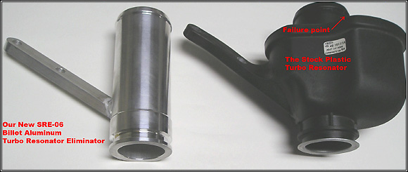 work
on a Sprinter (the one six blocks away in Richfield
was not one of them), and the dealer who would consider looking at the
problem before the end of the week was 200 miles north in Ogden. So,
two days later, Jack Hansen, a helluva nice guy from Jorgensen’s
Towing, arrived in the morning with a platform tow truck and carefully
winched the RV on the back, made Judy and the dogs comfortable in the
back
seat of the truck, hopped in the front with Hughes, and, with as
much dignity as we could muster, drove us four hours north to Hinckley Dodge
in Odgen. There Jack gently lowered the RV off the back of his truck
and
turned us over the Hinckley, who said they might be able to look at the
problem before the close of work that day. In the meantime, they called
the nearby pet-friendly Comfort
Suites who had room available. We spent
the night (at our expense): we read, checked email, and watched watched
some TV, we walked the
dogs on their well watered grass, enjoyed free drinks during their
one-hour happy hour, ate a great dinner at Cactus Reds, and
generally stayed inside to avoid the 104° weather outside. In the
morning, after a great complimentary breakfast buffet at Cactus Reds,
we
got a call saying that the problem was identified: a failed turbo
resonator (the black object on the left). They did not have a
replacement in
stock and someone was on their way to Salt Lake City to bring one back.
We could expect the repair by early afternoon.
work
on a Sprinter (the one six blocks away in Richfield
was not one of them), and the dealer who would consider looking at the
problem before the end of the week was 200 miles north in Ogden. So,
two days later, Jack Hansen, a helluva nice guy from Jorgensen’s
Towing, arrived in the morning with a platform tow truck and carefully
winched the RV on the back, made Judy and the dogs comfortable in the
back
seat of the truck, hopped in the front with Hughes, and, with as
much dignity as we could muster, drove us four hours north to Hinckley Dodge
in Odgen. There Jack gently lowered the RV off the back of his truck
and
turned us over the Hinckley, who said they might be able to look at the
problem before the close of work that day. In the meantime, they called
the nearby pet-friendly Comfort
Suites who had room available. We spent
the night (at our expense): we read, checked email, and watched watched
some TV, we walked the
dogs on their well watered grass, enjoyed free drinks during their
one-hour happy hour, ate a great dinner at Cactus Reds, and
generally stayed inside to avoid the 104° weather outside. In the
morning, after a great complimentary breakfast buffet at Cactus Reds,
we
got a call saying that the problem was identified: a failed turbo
resonator (the black object on the left). They did not have a
replacement in
stock and someone was on their way to Salt Lake City to bring one back.
We could expect the repair by early afternoon.
At 2:00, we got picked up at the
motel and brought
back to Hinckley Dodge to reclaim the RV and head out of town. Since we
had already missed our reserved dates at Kodachrome Basic we decided we
needed to head more directly to Kanab, which was our ultimate
destination. So, we drove back down to the Richfield KOA in time for
dinner. That evening, we walked the dogs over to Rotary Park to watch a
softball game and we happened to pass by a familiar tow
truck parked alongside the driveway of a house in the neighborhood.
Looking over the fence we saw Jack Hansen working on something in his
back yard and called out to him. He remembered us (it was just a day
ago) we and spent some time chatting with him. He was friendly and
talkative on the drive up to Ogden, and he was just as friendly that
evening. A really nice fellow. We told him, of course, what had
happened and he hoped that our trip would be smooth sailing after this.
And not to keep anyone in suspense, we did have smooth sailing for the
rest of the trip. [Two weeks after we returned home, Hughes ordered and
installed the aftermarket “turbo
resonator eliminator” (see above) that removes the worry of ever
having
problems again with this part failing. If you own a Dodge Sprinter and
wonder if you could replace this yourself, remember that Hughes, who’s
never even changed the oil in a car, was able to accomplish this within
an hour.]
BACK
ON
TRACK
In
the morning we headed south on US 89 knowing that we had a night to
spend before arriving in Kanab, though we
had no place in mind. We drove along the scenic Sevier River through
Circleville, where
Butch Cassidy grew up, and arrived in Panguitch,
which we learned was holding a hot
air balloon festival and motorcycle
rally that day and the next. They even advertised a 5K race in the
morning. This sounded like a good place to stop.
Panguitch is about as big as Nederland
(1,400), but
there was a lot of
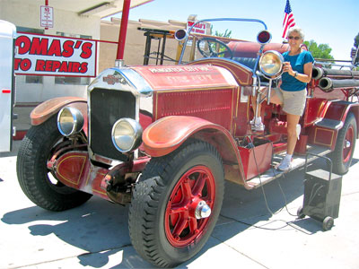
public enthusiasm, noise from the motorcycles, a short but colorful
parade featuring a remarkable antique fire engine that they run in the
parade every year, a
good dinner to be had at the Cowboy’s Smokehouse Cafe.
and a Lions Club pancake breakfast in the morning after the balloons
ascended. The runners in town couldn’t get their act together so the
5K race was canceled to Judy’s disappointment. We biked all around,
window shopped, talked with folks, and visited what used to be the town
library which, like the
one in Richfield, is a Carnegie Library.
It had been sold to 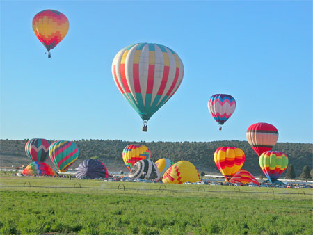 an
antique
dealer and the books moved elsewhere. After dinner, we listened to
a
young girl gamely give a harp concert on the main street, competing
with juiced up bikers showing off their hogs, and with semis hauling
freight
through town. We think the trucks and bikers won, but we gave the girl
gold stars for sticking with it for an hour. What a tough gig!!
an
antique
dealer and the books moved elsewhere. After dinner, we listened to
a
young girl gamely give a harp concert on the main street, competing
with juiced up bikers showing off their hogs, and with semis hauling
freight
through town. We think the trucks and bikers won, but we gave the girl
gold stars for sticking with it for an hour. What a tough gig!!
Our “campground” that night was the
parking lot of
the Garfield County Courthouse—shady enough, level, and in no one’s
way. At 6:00 a.m. we got up and walked half a mile to the field on the
edge
of town where we watched about 30 balloons ascend over the valley: a
beautiful
sight in the light of sunrise. We ate our fill of pancakes, eggs,
sausage, bacon, orange juice, and good coffee for $5 apiece, thanks to
the Lions Club. Then we headed south on US 89 for Kanab.
We had enough time, we thought, to take
a quick look
at Kodachrome
Basin where which we’d heard so much about and where we had
planned to camp if the turbo resonator had held up. The park was just a
short 30 miles down State Highway 12. However, we had not gone ten
miles off the highway when we approached Red Canyon
Pass near the
entrance to Bryce
National Park. We stopped at a pull-out to take some pictures of
the red sandstone formations and we noticed a 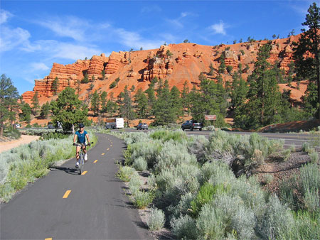 newly paved bike path
paralleling the road and a trail head. We pulled into a shady spot and
set off for at least the top of the pass about six miles away. It was a
nice break and a good bit of exercise for us both. We’re not sure how
far the path extends; we will look for it when we pass this way again.
newly paved bike path
paralleling the road and a trail head. We pulled into a shady spot and
set off for at least the top of the pass about six miles away. It was a
nice break and a good bit of exercise for us both. We’re not sure how
far the path extends; we will look for it when we pass this way again.
Back on US 89, we drove through
Mt. Carmel, gateway
to Zion
National Park and home of the Thunderbird Foundation
that honors western artists Maynard
Dixon and
Edith
Hamlin; we must visit
there when we return to Kanab.
We passed two entrances to Coral Pink Sands
State Park which we will visit again, but only during a
cooler
season. We went by the popular tourist attraction Moqui Cave just
outside Kanab, another place to visit when we come back. We checked in
at the Kanab RV Corral,
found a shady spot, plugged in and got the A/C
going for the dogs, took a swim and read by the pool until the sun set
and the temperatures relaxed into the 70s.
We biked through Kanab looking in the
store windows (would you believe we saw bagpipes for sale in the window
of a music store?),
finding out where things were, and what was going on the coming week.
In the morning, Judy ran before the heat of the day made it
impossible, and then we checked out and headed for our home for the
next five days:
Best Friends
Animal Sanctuary. Our experience there was so rich and
varied
that we created a special
web page with details and photos of that
portion of our trip.
RETURNING
TO COLORADO
•Old Paria.
Our time at Best Friends was rewarding and very satisfying, and we’ll
do it again, but not in the summer. The hot weather continued to dog
us,
and we figured we needed to get to
higher elevations to find any 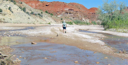 relief. We had one stop we wanted to make as we
left Kanab: tracking down the ghost town of Old
Paria. The
maps showed it to be about 30 miles east of Kanab and another six or so
miles
off US 89 to the north. The six miles of washboard gravel was rough in
some
places, shaking the contents of drawers, the refrigerator, and storage
compartments. We passed the burned out remains of “Paria,” a replica of
a western town used to film movies and TV westerns. About two miles
past the Pahreah Cemetery, as isolated a
resting place as we’ve seen, the road became safe for 4-wheel drive
vehicles but not for a 5-ton RV.
relief. We had one stop we wanted to make as we
left Kanab: tracking down the ghost town of Old
Paria. The
maps showed it to be about 30 miles east of Kanab and another six or so
miles
off US 89 to the north. The six miles of washboard gravel was rough in
some
places, shaking the contents of drawers, the refrigerator, and storage
compartments. We passed the burned out remains of “Paria,” a replica of
a western town used to film movies and TV westerns. About two miles
past the Pahreah Cemetery, as isolated a
resting place as we’ve seen, the road became safe for 4-wheel drive
vehicles but not for a 5-ton RV.
We parked under a shade tree,
turned
the
dogs loose to romp through the shallow stream, took our water bottles,
hats, and sandals and began hiking in the direction of the tracks,
hoping to find where the gold
miners built the camp they called “Pahreah.” Two miles up Paria
River we decided that the 4-wheel drive tracks we followed would take
us to Salt Lake City if we followed them long enough. The heat, the
biting flies, and the hunch we missed a significant
landmark combined to encourage us to return to the RV and save the hunt
for another trip. Our dashboard thermometer showed 110°. On the way
out to the highway, we met up with a photography group led by a
fellow who knew the area well. He confirmed that walking upstream
led nowhere and that if we had simply crossed the creek where we had
parked the RV we’d have found the pitiful remains of the old mining
camp. Next time.
•Bluff.
Continuing east on US 89 we drove
past the Vermilion
Cliffs, dipped south into Arizona to the Glen Canyon
Dam at Page, crossed
the northern section of the Navajo Reservation through Kaibito, Black
Mesa, Kayenta, Monument
Valley, back into Utah, crossing the San Juan
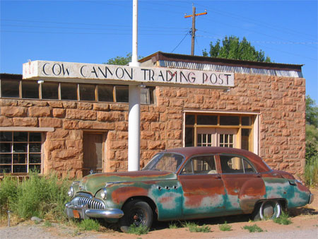
River at Mexican Hat. We finally arrived in Bluff, a town made
famous by the
Mormon settlers whose efforts to reach and tame this fertile valley for
Brigham comprise a memorable chapter in Utah/church history. We like
staying there because we know we are going to dine on gourmet
cooking—surprise!—at a restaurant that has the appearance of a
deserted, derelict structure from out of the past: the Cow Canyon
Trading Post (whose web site is the most succinct of any on the
web). The rusting truck and early 1950s Buick haven’t moved for
years, and the weeds growing up around the tires confirm that. Hughes
discovered the place a few years ago when he and grandson Griffin ate
there before rafting the San Juan River.
How they’ve stayed in business
in this location is a testament to good management and great food.
•Transfer
Campground. We left Bluff early, aiming the
RV east toward Colorado. We crossed over at the Ute Mountain
Ute Reservation, filled with diesel at the casino at Towaoc, and
cruised
into Cortez, which looked much more prosperous and up-and-coming than
we remembered from the last time we were through. Another 20 miles east
took us to the Mancos Valley where we turned north toward Mancos State
Park, once known as Jackson Lake before the state took it over. We
were
turned away! They were full for the weekend, but another five miles up
the dirt road was Transfer,
a national forest campground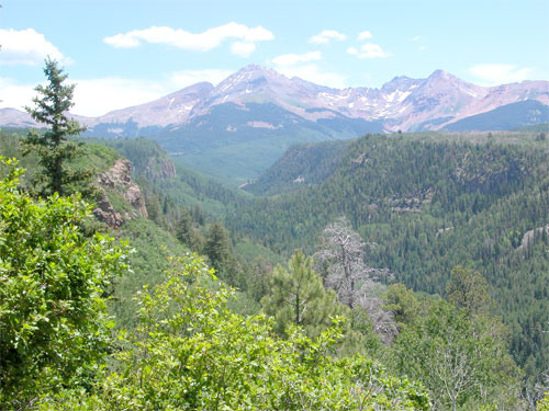 with a few
sites left, all of them good. As it turns out, we were glad the state
park was full: they had no facilities except a boat ramp for all the
power boats that would be zipping around the lake all weekend—not our
idea of a great place to camp, plus they wanted $19/night for the
privilege. Transfer, on the other hand, offered good shade, lots of
good hiking, wildlife and wild flowers, and incredible views of Mt
Hesperus, one of the four mountains sacred to the Navajos. Dry camping
in an aspen grove for $6/night seemed a bargain. We took the
dogs down the “Big Al” trail, a flat, smooth, wheelchair accessible
trail
named after a firefighter who was injured and disabled fighting the
Yellowstone fire in
1988. We saw deer and plenty of
birds, and the dogs chased squirrels. At the end of the trail the view
of Mt Hesperus and the Mancos
River valley was fantastic. Later, we left the dogs in the RV and hiked
to bottom of the valley, a steep descent, and then a couple of miles
along the
river before making our way back up to the return trail to the
campground. At 8,500’ elevation, we finally found the cooler
temperatures we were looking for and our stay at Transfer was
delightful.
with a few
sites left, all of them good. As it turns out, we were glad the state
park was full: they had no facilities except a boat ramp for all the
power boats that would be zipping around the lake all weekend—not our
idea of a great place to camp, plus they wanted $19/night for the
privilege. Transfer, on the other hand, offered good shade, lots of
good hiking, wildlife and wild flowers, and incredible views of Mt
Hesperus, one of the four mountains sacred to the Navajos. Dry camping
in an aspen grove for $6/night seemed a bargain. We took the
dogs down the “Big Al” trail, a flat, smooth, wheelchair accessible
trail
named after a firefighter who was injured and disabled fighting the
Yellowstone fire in
1988. We saw deer and plenty of
birds, and the dogs chased squirrels. At the end of the trail the view
of Mt Hesperus and the Mancos
River valley was fantastic. Later, we left the dogs in the RV and hiked
to bottom of the valley, a steep descent, and then a couple of miles
along the
river before making our way back up to the return trail to the
campground. At 8,500’ elevation, we finally found the cooler
temperatures we were looking for and our stay at Transfer was
delightful.
•Teal Campground.
We debated staying another night at
Transfer, but when Judy returned after her morning run, we decided to
push on to the Pagosa Springs area where we could enjoy the 4th of July
festivities. We packed up and drove through Durango and into Pagosa
Springs to the Pagosa
Riverside RV park, just two miles east of town on
the banks of the San Juan River. We wanted shade, utilities, and to be
within
biking distance of town. They were pretty full, but we were able to
make reservations for two nights, July 3-4. Having that in place, we
backtracked through town and turned north on Piedra Street for 23
miles, past some pricey suburban 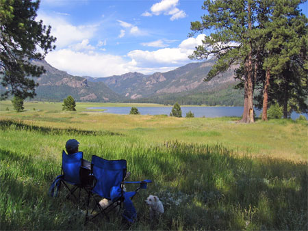 developments and some
expensive trophy homes on acreage, past a few remaining ranches, and
into
the San Juan National Forest ending at the trailheads that access
the Weminuche
Wilderness Area. This is a gorgeous area in a state where
there are lots of beautiful areas.
developments and some
expensive trophy homes on acreage, past a few remaining ranches, and
into
the San Juan National Forest ending at the trailheads that access
the Weminuche
Wilderness Area. This is a gorgeous area in a state where
there are lots of beautiful areas.
Michael
and Cindy had camped at William Creek
Reservoir
last May and came back with glowing reports and enticing photos
on their web site. Teal
is a national forest campground with large
sites along the west shore. The views across the water to the high
mountains to the north are as pretty as any we’ve seen in the state.
Cimaronna is a small (11 sites) attractive campground two miles further
north at
the trailhead for the Cimaronna Trail. Both campgrounds have vault
toilets and water spigots, no utilities, and very quiet. The
lake/reservoir is a popular fishing area; boats are permitted but speed
boat folks seem to go somewhere else. We set our folding chairs in the
grass beneath a stand of shady trees, put the dogs on long leashes, and
did a lot of sitting and looking for two days. The temperatures were
warm and the direct sun was pretty hot, but nothing
like
the heat of the past two weeks. However, between lunch and dinner, we
spent time in the shade reading and relaxing—cocktails a 5:00 of
course. Even Sophie and Bella were happy to lay quietly next to our
chairs in the tall grass.
We biked up to the end of the dirt
road, checked out
the Cimaronna campground and a mile further the campground restricted
to folks with
horses. We hiked portions of both the Williams Creek Trail and the
Cimaronna Trail while we were there, but neither of them long
enough to reach a “destination” (lake,
mountain pass, etc.). We walked to the south end of the William Lake
and
across the dam and turned around when the trail on the other side
petered out. On our
last day, on our way back to Pagosa, we stopped to hike on the Piedra
Trail along Williams Creek below the reservoir only to discover it was
overgrown with poison ivy, so we turned around after less than a
quarter of a mile. There was a nearby picnic area along the creek,
which was a perfect place to dunk the dogs to clean off
as much dust and dirt as possible and cool them off at the same time.
Our two days at Teal have been pleasantly relaxing. The unexpected
mid-day heat did slow us down but we found it easy to relax.
•Pagosa
Springs.
When we got back to Pagosa
Springs, we shopped for groceries and
returned to the Riverside RV park, checked in and were assigned a spot
right on the river, though with no hook-ups, at least for that night.
So we drove into town to find out the schedule for the holiday
activities, and walked the dogs along the riverwalk where an arts and
crafts fair was spread out through the downtown area. There was not
much of interest to us,, but we got the schedule of July 4th events,
and
returned to the shade of the campground, hot showers, a late supper,
some more gin rummy, and then to sleep.
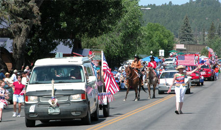
The parade in the morning was quite a
surprise. It
lasted an hour and a half, featured a marching band, lots of horses and
a 4-wheel drive club, one old car (a Model A) a couple of fire trucks
and an ambulance, floats from various groups including the
library, and individuals like the Jicarilla Apache beauty queen and
princesses,
the mayor who seemed to be running for re-election, and veterans from
wars dating back to WWII. There were upwards of 10,000 spectators who
lined Pagosa Street (US 160) seeking shade under trees and umbrellas.
For a town of 1,500 people, it was an amazing turn out. It
made the parade in Nederland (population 1,400) seem a very local affair by comparison. After
the parade, we bought another tire for Judy’s bike (we had discovered
in
the morning that now her front
tire and tube had large holes in them) and
we returned to the campground to move into our new site with
hook-ups. We turned on the A/C, ate lunch, mounted Judy’s new tire and
tube, and then stayed inside while the thunder boomed and a strong but
brief rain fell (as did the temperatures). We fed the dogs and rode our
bikes to
town to catch some real rodeo, had a fantastic Mexican dinner at
Tequila’s (don't miss this place if you're in town), and headed to the
high school football field for a lively
bluegrass concert that preceded the fireworks. We biked back through
town and along the highway to the RV park in the dark with only our
headlamps to guide
us (not too smart, but we were careful enough and the traffic was
thankfully light).
Of course one of the main attractions
in Pagosa are
the hot springs. In the morning, while Judy did her morning run, Hughes
packed the RV for the road, leaving out clean clothes and towels. The
facility at the hot springs is very clean, organized into different
pools at different temperatures, accessible to the San
Juan River for the occasional cold soak, and very scenic. It’s one of
our favorites among the several dozen in the state we’ve visited. All
day admission for two seniors including lockers was $28.50 We spent two
hours
in pools ranging from 98°–107°. The post-soak shower cleaned us
completely, and 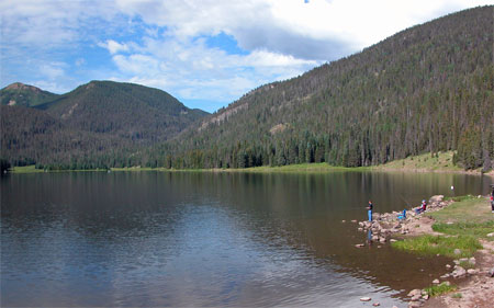 we
left town relaxed, refreshed, and smelling good.
we
left town relaxed, refreshed, and smelling good.
We loved Pagosa Springs! It is
scenic, small enough
for comfort yet with all the services and retail opportunities a person
would need, and there are lots of outdoor activities, which add up to
a great place to visit.
•Big Meadows.
Wolf Creek Pass
tops out at 10,800' and is a good pull for any vehicle. The RV pulled
right up without hesitation—even passed a
car and a truck on the way up. As we came down the north side we headed
for Big
Meadows, a national forest campground on the shore of
a reservoir just a two miles from the highway. We didn’t know
anything about the place and were prepared to move on to one of the
several other campgrounds in the area if this wasn’t to our liking.
However, the setting was beautiful, campsite #8 (the prettiest one in
the park Bobbie Chapman, our camp host, assured us) was empty, and we
pulled right in with great access to the water and a view of the lake
and the mountains surrounding it. There was a floating dock folks were
fishing from, as well as trails to fishing spots around the shore and
several quiet boats
in the water from sunup to sundown. Hughes was even moved to toss a
line in the water and try his luck—and he didn’t get skunked! We
walked the dogs along the water and on a short trail within the
campground area that led to Cascade Falls and a cluster of columbines
on the slopes. On the way we spotted an elegant 8-point mule deer with
the healthiest coat of any deer we’ve seen in a long time. He was wary
but not frightened by our presence. By the afternoon, the 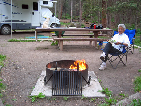 dark
clouds
got together and watered the dust. The dogs napped and we read. By
evening we had our first campfire of the trip and at 9,300’ we
appreciated the warmth.
dark
clouds
got together and watered the dust. The dogs napped and we read. By
evening we had our first campfire of the trip and at 9,300’ we
appreciated the warmth.
The thermometer read 41° in the
morning, quite a
change from the past three weeks. Judy ran and Hughes biked to Shaw
Lake, a small fishing lake another three miles above Big Meadows at
10,000'. There were already several folks along the shore with their
lines in the water. Even so, it was quiet, still. Later in the morning
we took the dogs on a hike around the lake through tall grasses, small
feeder streams, and the spruce and fir trees that give off a thick
aroma like the small sachets of balsam fir needles that folks of
another
generation used to keep in their drawers of linen or clothing.
That’s how the
forest smelled. It was intoxicating.
Like Teal campground up on William
Creek, this has
been “real” camping (though an RV with lights, running hot water, flush
toilet and shower, [broken] TV, etc. is not the same as sleeping on the
ground in a lean-to): no highway noise, but the constant sound of water
from a small creek that feeds the lake. Kids are fishing, running
around, crying occasionally, and multi-generational family groups
sit around campfires in the evening talking, telling stories, or
just being quiet. This is not an RV park, which is fine, though we
do miss the electric hook-ups and wi-fi. But that’s the trade-off,
isn’t
it?
•Mt. Princeton
Hot Springs. We
got an early start heading to Mt. Princeton Hot
Springs, 200 miles north between Salida and Buena Vista. We hoped
for a
spot in a national forest campground within biking distance of the hot
springs. These often have some first-come, first-served sites, so the
sooner we got there the better chance we’d have of getting something
we’d
like. We had done pretty well so far.
Our route took us through the heart of
the San Luis
Valley, home of the best potatoes you can buy. Sorry, Idaho. Sorry,
Maine. Colorado’s are tops. We grow whites, yellows, reds, purples;
mashers, bakers, or boilers. Don’t pass them by when you see them in
the stores. It is no surprise, then, that we drove a few miles out of
our way to the tiny town of Center where potatoes are boxed ready
for shipment. We stopped at Pepper’s Potatoes and talked with Rod about
buying a small quantity. The potatoes are usually packed in 50-pound
boxes, but Rod showed us 15-bags he assured us were fresh: “We just
made them this morning,” he said proudly. Five bucks for 15 pounds of
premium Colorado potatoes is a good buy anytime, especially when they
are “just made.”
We drove west off US 24 at Nathrop
(between Salida and
Buena Vista) as though we were headed to
St. Elmo, a well
preserved ghost town just below the Alpine
Tunnel. We followed
Chalk Creek past the hot springs, several miles further past the first
campground that was full and finally to Chalk Lake Campground which had
several sites available. The setting along the creek was lovely, the
hike across the road up to Angie Vaille Falls was a welcome surprise,
but the distance to the hot springs seemed too far to bike in the
time left in the day. So we decided to put that off until the morning
and planned to
leave this area, as we did Pagosa, clean and fresh smelling.
In the morning Judy ran from the
campground to the
hot springs, about 5 miles. Hughes packed up and drove there with the
dogs. We did spend time at the hot springs, which did not compare
favorably with the facility at Pagosa Springs. The hot springs facility
consists
of two swimming pools with temperatures in the mid-ninety degree range,
plus informal places along Chalk Creek where you can build a little
sit-down place to trap the hot water as it seeps out of the riverbank.
You can
heat your bottom and freeze your feet (or by turning around, reverse
the situation), but no way can the hot and cold water really be mixed
to create a uniform temperature. The rest of the facility looks in dire
need of
remodeling and refurbishing. It’s approaching dingy. We didn’t stay all
that long, though we did shower and clean ourselves up so that we would
be “presentable” when we met up with Judy’s cousin Carol and her
husband,
Ken, at Mueller State Park.
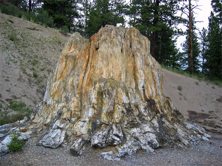
•Florissant
Fossil Beds National Monument. We stopped in Buena Vista
for some groceries, drove over Trout Creek Pass (a mere 9,346'), and
across the lower end of South Park (for those of you from out of state,
there really is a South Park,
though the resemblance between the cartoon show and the real place is a
giant stretch). It rained seriously for much of the trip and the wind
did its best to knock our RV over. We stopped at Florissant Fossil Beds
National Monument. We went into the
Visitors Center and, because it was threatening more rain, watched a
video about the fossils and the development of the national monument,
and asked some questions about what we might do when we returned the
next day. We were encouraged to take the ranger-led hike at 10:30 in
the morning. It turned out this was two hours well spent. The walk was
informative and leisurely across the open fields where the
fossilized redwood tree stumps are exposed. We sorted through some
shale outcroppings for leaf and insect fragments from the Eocene Epoch
(therefore, 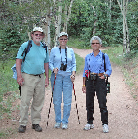 no dinosaurs). We learned a good
deal about the
wildflowers and the plant life in the area, which are a lot like
Nederland. And we learned about why the monument was finally created in
1969: to save
the fossils and the area from developers who intended to sell parcels
so that each home could have a fossil tree stump in its yard! In
addition, over the years, stumps were sold (Walt Disney personally
purchased one for Disneyland) or stolen during various midnight
requisitions.
no dinosaurs). We learned a good
deal about the
wildflowers and the plant life in the area, which are a lot like
Nederland. And we learned about why the monument was finally created in
1969: to save
the fossils and the area from developers who intended to sell parcels
so that each home could have a fossil tree stump in its yard! In
addition, over the years, stumps were sold (Walt Disney personally
purchased one for Disneyland) or stolen during various midnight
requisitions.
•Mueller
State Park. We had been in contact with
Carol and Ken who were suffering from some pretty good heat at their
home in Milliken, near Loveland. We knew that Mueller was a popular
state park, it was on the back or west side of Pike’s Peak, and sat at
about 9,000’. It would be cool. Both of us were able to make
reservations
which were necessary at this time of the year. We arrived a day before
they did and spent the first night between visits to the National
Monument.
Ken and Carol arrived the afternoon of our second visit to see the
fossils. They gave us an update of the heat we had missed at home while
we were in Utah. Both Colorado’s Front Range and Utah sounded too hot
to be enjoyable. Mueller offered us relief.
Mueller
State Park is 5,000 acres of lush meadows and spruce and
aspen forests, a terrific place not only to find relief from the heat,
but also has excellent hiking, biking,
and horseback riding. The park has a well marked 50-mile trail system
that
goes
through fields of wildflowers, aspen groves, small ponds, and rocky
overlooks. The campsites offer only electric hook-ups; we saw many
folks
walking from the water faucets to their trailers/fifth wheels/RV with
5-gallon containers refilling their water tanks—a mild inconvenience.
The roads to the sites are paved, as are the parking
pads, which keeps the dust down. Dogs, however, are not made to feel
welcome:
they are not allowed on the trails and must always be on leash only in
the campgrounds—a major inconvenience for those of us who like dogs,
and most folks camping there had dogs. There is regular patrolling of
the area by the ranger watchdogs looking for violators (i.e., loose
dogs). On some days the same guy drove by every 10 minutes. Come on
folks, lighten up. 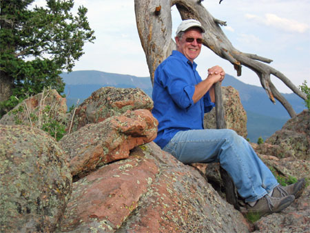
Nevertheless, we hiked a good deal,
Hughes biked
several routes, and Judy ran several days while we were there. We
walked
much of the
six-mile Chessman Ranch Trail that skirts aspen groves and across
fields over wide, smooth, well-maintained trails, stopping to look at
the wide variety of
wildflowers. Our pace was leisurely; our objective was not to
make time or make miles, but rather to enjoy the incredibly nice
weather, the scenery, and our company. When we got back, we built a
fire and got a good bed of coals ready so we could treat Ken and Carol
to a Colorado potato dinner topped off with
cheese, chopped green onions, butter, some Mrs. Dash plus a salad and a
bottle of red wine (though we were prepared to swear it was cranberry
juice if stopped by the alcohol watchdogs). Judy cooked the potatoes in
the
oven and we finished cooking them in the coals wrapped in foil.
Delicioso! We continued to feed the campfire until about 8:00 when it
was clear we all needed to go to bed. After three nights at Mueller, we
packed up in the morning, looking forward to sleeping in our own bed
that night. We’d been on the road for a month and visited some
beautiful and interesting places. While we enjoyed our trip, there’s
nothing like your own bed. We arrived home with two new functioning
batteries, a new turbo resonator, and a dead TV.
AND
FINALLY...
We’ll leave with this photo
of the west or “back” side of Pikes Peak taken from Mueller State Park.
The dark areas on the aspens are the result of elk eating the bark, a
common 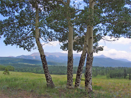 sight
throughout this park. This area is not so well known to those folks who
hurry up and down the interstate between Pueblo and Fort Collins.
Getting on the other side of the Front Range opens up a views like this
everywhere you look. It’s the Colorado of the calendars, the tourist
bochures, of small towns, large ranches, and forests of pine, spruce,
fir and aspen. Mueller State Park, like so many of the camping areas of
Colorado, opens a door to the scenery and serenity of our state.
sight
throughout this park. This area is not so well known to those folks who
hurry up and down the interstate between Pueblo and Fort Collins.
Getting on the other side of the Front Range opens up a views like this
everywhere you look. It’s the Colorado of the calendars, the tourist
bochures, of small towns, large ranches, and forests of pine, spruce,
fir and aspen. Mueller State Park, like so many of the camping areas of
Colorado, opens a door to the scenery and serenity of our state.
We are planning to do more and
more of this kind of travel. We’ll still
do an occasional foreign trip—the Galapagos, Scandanavia, Ireland, and
even a third trip to New Zealand are just a few places we’ve
talked about in the future. But we’re thinking two or three 4–8 week
road trips a year in the US (including Alaska) and Canada are about
right for us. There are places we want to see again or for the first
time, and there are 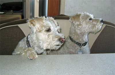 friends
in all parts of the country we want to
visit. RV travel seems to be comfortable for us and we enjoy the
company
of Sophie and Bella while we’re on the road.
friends
in all parts of the country we want to
visit. RV travel seems to be comfortable for us and we enjoy the
company
of Sophie and Bella while we’re on the road.
For those of you wondering,
here’s the cumulative score of our
on-going gin rummy game: Hughes won 5,825 to 4,874. We played 293
hands (roughly 10/night). We’ll start a new game of gin rummy on our
next big road trip in the early fall. We’re heading to Washington/Idaho
for a family visit and then down to Ojai, in southern California, for
Hughes’s 50th high school reunion. Where we’ll go on our way to
Washington or going home from Ojai is still in the planning stages. But
we’re pretty sure we’ll have a great time on the road. Dogs, too.
