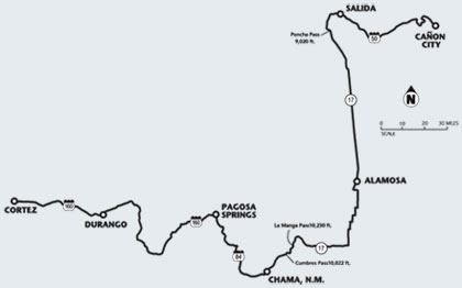
 June 18–23, 2006
Let me be very clear right up front:
I am not an avid bicyclist. Prior to this event I’d never ridden more than
72 miles in a day and that was over 30 years ago in Michigan. About ten
years ago I did ride a “century” (100K/62 miles) in the first two years
of the Boulder Bicycle Classic on the flatland between Boulder and Loveland.
I do enjoy both casual road and mountain biking from time to time. I’ve
done some hill climbing (e.g., Vail Mountain and Shrine Pass here in Colorado)
and some easy mountain biking in our area. A few years ago I rode about half of the
Kokopelli Trail before
the rest of the group aborted the ride; I’d like to go back and do the entire
route. Judy and I usually take our bikes to Sedona for some off-road biking there.
I’ve even ridden from Nederland to Boulder (18 miles of screaming downhill)
but never the other way up. My idea of a pleasant ride is 20 miles through Boulder
on one or more of the gentle paved bike paths, or from Boulder east to Michael and
Cindy’s house for an hour on a Sunday morning while Judy is running with the
Boulder RoadRunners.
What follows may be of interest to those who are, or might in the future consider,
joining a similar bicycle event. This fairly lengthy entry is from my notes written
at the conclusion of each day of the Ride.
If you were on the 2006 Ride the Rockies
I’d look forward to your recollections that add to what you read here.
—Hughes
THE BEGINNING
I confess that when I learned I was accepted (how that happened
is another story I share only in private) I faced several months of Judy’s urging
me to train (which I didn’t do much of) and a growing apprehension that maybe
I’d find myself in way over my head.
Judy and I bought bikes when we moved to Colorado in 1992: Specialized
“Hard Rock” bikes that we could use off or on road depending upon what tires
we used. We accessorized them with kick stands, racks, and side mirrors, giving no thought
to added weight or the notion of wind resistance. The bikes have done us well for the
limited use we’ve given them over the past 14 years. I could see no reason to
ride anything else.
Thanks to Don Hayes, a runner friend who completed a much more difficult
RTR course just a few years ago when he was in his early 70s—as well as to my usual
stubbornness and foolish pride—I persisted. Don assured me that, barring injury,
really foul weather, or mechanical calamity, I shouldn’t have any trouble finishing.
After all I’d climbed Kilimanjaro, trekked in the Himalayas, completed New Zealand’s
Milford Track, and hiked the Inca Trail: I was strong enough, fit, and could easily average
15-18 mph which would get me to the next stop each day well before they cleared the course.
He reminded me that it’s not a race, but an event. Getting to the next overnight
stop is the goal; when I got there didn’t matter.
What follows is my edited (for clarity) journal I kept during the trip.
It serves as my memory and, if nothing else, proves that if I can do it, you probably
can also.
GETTING TO THE START: JUNE 17
I parked my car for the week in the Coach USA parking lot in Golden.
I certainly wasn’t the first one there at 6:30 in the morning. A crowd of excited
folks filled the parking and loading area with their duffles, suitcases, boxes, trash cans,
and bikes in cardboard cartons (like mine) and hard plastic carrying cases. They were
saying good-bye to their drivers or families or were milling around waiting to put their
 bikes on a truck and their duffles in the luggage area of one of the three buses that
would take us to Cortez. Everything seemed well organized: there were lots of volunteers
with lists and names of who had bought their ticket, checked in, where their bikes went,
luggage tags, bus assignments, etc.
bikes on a truck and their duffles in the luggage area of one of the three buses that
would take us to Cortez. Everything seemed well organized: there were lots of volunteers
with lists and names of who had bought their ticket, checked in, where their bikes went,
luggage tags, bus assignments, etc.
We pulled out shortly after 7:00 and headed down to US 285 south and west
to Johnson City for a half hour coffee break, and on to Pagosa Springs for a lunch stop.
We were in Cortez about 4:00 in the afternoon, well before the trucks with the bicycles
which arrived an hour or two later.
I rode the bus with a very nice fellow from Lakewood
who was also doing his first RTR. Mark is lean, tan, and all muscle from
riding his bike to work almost every day. He told me he splurged on a new
bike for the Ride: some turbocharged, sleek, model that weighs far less
than my old clunker.
Note: A month later,
Mark finished 9th in his age group in the really tough
Bob Cook Mt. Evans Hillclimb,
a 28-mile grind on pavement from Idaho Springs (7500') to the summit of Mt. Evans
(14,200'). The grade is rated from 5% to 15%. I can’t imagine taking
that on. Way to go, Mark!
Montezuma County High School in Cortez, the official
headquarters for the RTR start, swarmed with thousands of riders, staff
and volunteers, families, and curious townsfolk. I got my tent up quickly,
one of hundreds in the tent city that sprawled higglety-pigglety on the
lush grass around the high school buildings, particularly in shady areas
or on the football field. Quite a few claimed a spot in the high school gym
where the tentless shared the hardwood floor with other riders and their
air mattresses, sleeping bags, clothes, and other personal gear. These folks
were advised to bring earplugs and eye masks. Duh!
Official registration didn’t take long; again things
were well organized. There were lines, but we moved quickly thanks to dozens
of volunteers, preprinted lists, materials packets (including the valuable
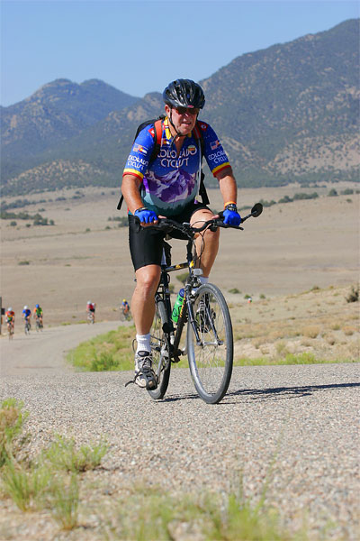
route guides listing altitudes and distances for each day), and size-sorted
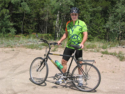
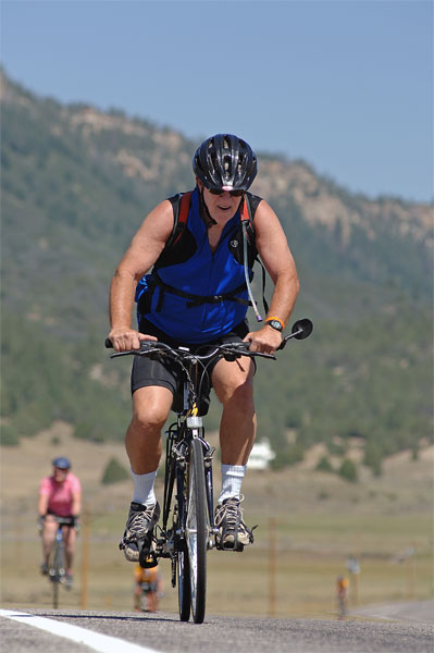
piles of official RTR jerseys (the lime green and orange one I’m wearing
in the first photo above), official water bottles, and numbered wrist bands.
Don had advised me to sign up in Cortez for daily massages during the Ride.
I decided two half hour sessions would be sufficient.
By dinner time, the air had cooled to the mid-80s and a good
westerly breeze continued. I bumped into the only person I knew before the Ride:
Heidi Van Everen, who owns
Timberline Builders
in Nederland with her husband, Mark, was riding with an old Middlebury College
friend. The three of us had dinner that evening at The Homesteaders, which
my former neighbor, Fred Rodak (who moved to Cortez for a short while),
claimed was the only decent restaurant in town. The pasta was just fine,
but the homemade wild blueberry pie was an outstanding treat.
I slept well that evening knowing that the night temperature
at 6100' would cool nicely into the low 40s. I set my alarm for 5:00 a.m.
I figured an early start would assure me of getting to Durango before dark.
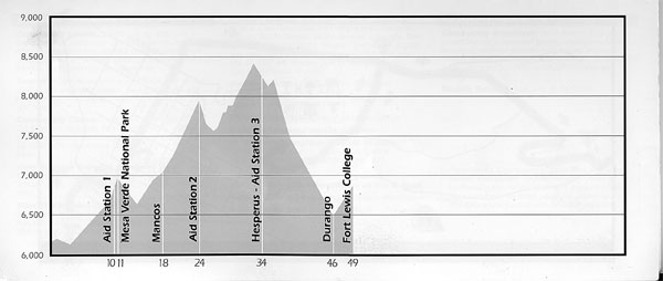
RTR Day 1: June 18 •Cortez
to Durango: 49 miles, 3600' elevation gain
 I was up before 5:00 a.m. without the benefit of my
alarm which, it turns out, I hadn’t set properly anyway. It may have been
the excitement and anticipation that woke me; it probably was the sound
of tent and sleeping bag zippers all around me. Whatever it was, I was
awake and alert, dressed, packed my gear and lugged my one bag (which included
my clothes, tent, sleeping bag—everything in one duffle) to the “early”
truck that would carry my stuff to the next stop. Breakfast was served in
the high school cafeteria ($5) and I was on the road shortly after 6:00.
I was up before 5:00 a.m. without the benefit of my
alarm which, it turns out, I hadn’t set properly anyway. It may have been
the excitement and anticipation that woke me; it probably was the sound
of tent and sleeping bag zippers all around me. Whatever it was, I was
awake and alert, dressed, packed my gear and lugged my one bag (which included
my clothes, tent, sleeping bag—everything in one duffle) to the “early”
truck that would carry my stuff to the next stop. Breakfast was served in
the high school cafeteria ($5) and I was on the road shortly after 6:00.
The early morning temperature was 45°. Volunteers were already out on the route to
make sure we got out of town and safely onto the highway. (This was true in every town.) The route to
Durango followed US 160 past the entrance to
Mesa Verde National Park, through the
Mancos valley,
to the summit at the Hesperus Ski Area and the long downhill into Durango.
As I was rushing headlong down that descent at 40 mph, there was a fellow
hoisting his bike off the road and over the guard rail. I had enough time
to call out if he was OK and heard him yell back something like “frightened”
and being “freaked out.” I have no idea what happened to him after that.
After the cool start, the sun came out in perfect Colorado weather and the
temperature was soon in the 80s. The scenery on this stretch is magnificent: the beautiful
Mancos River valley is surrounded by hillsides of healthy pine and fir. The “town”
of Hesperus is a post office and gas station/general store that serves the needs of folks who
live in “Durango West,” a relatively newer area of retirement homes, and also the
residents of the western section of the Southern Ute reservation. There are scores of National
Forest campgrounds to the north of the highway in the San Juan National Forest.
At 49 miles, this would be the shortest leg of the Ride, though it turned out
by no means to be the easiest. (My friend, Don, told me I would get stronger each day of the Ride.
By the end of the week I believed him.) Two long ascents were a good test for the first day out.
I wasn’t surprised that I was slow going and tired at the end. However, I was surprised at
the number of riders who found today’s ride as tough going as I did.
The grades were not steep, but they were 10 and 15 miles long. I probably averaged
between 5 mph and 8 mph on the grades. My legs felt like they were going to cramp but never did.
I drank a lot at each of the three rest stops as well as along the way. Just when I thought we
were done, there were about five more miles to cross town and head uphill to the campus of
Fort Lewis College where we would spend
the night. The last hill was a cruel joke to play on us after the long descent into town. I
arrived at the college just before noon: 6 hours total of riding and rest stops. The truth is
I was tired. And there are still five more days.
I pitched my tent on the football field where there was no shade but the grass
was thick and provided great cushion. I took a hot shower as soon as I could. It was cleansing
and relaxing. I would have been better advised to find a place in Durango to sit in the Animas
River and let the cold water heal my aches. But the hot water was soothing.
While I was in the shower, someone’s tent was blown off the field and into
the air, reportedly 500' high and far enough away that where it came down no one could say.
I guess the other fellow just put up his tent (no stakes) and left it. What a surprise he must
have had when he came back. I don’t know how the story ends. Did he recover his tent?
Did he spend the rest of the trip sleeping in school gyms along the way?
Did he sleep under the stars?
I took a shuttle bus into downtown Durango (there were shuttles in every town to
take us from where we were camped to the downtown area) and found great double iced mocha latte
at Magpie’s Newsstand Cafe across from the historic
Strater Hotel. I lounged in their shady patio
and read the Sunday paper, worked the crossword, and hoped to catch up with Mark for dinner.
I finally decided I’d sat long enough and stretched my legs by walking
several blocks through Durango: through the lobby of the Strater, the town’s gorgeous
victorian landmark (we really should stay there one night); past
Farquahrt’s, famous for their
tug of war teams at the Hardrockers Holidays in Silverton; I looked through the pots and rugs
and kachinas at the famous Toh-Atin Gallery;
I watched the trains come into the station where the
Durango-Silverton Narrow
Gauge Railroad is housed.
Note: There is much controversy today
about the smoke and cinders the train puts out being a danger to the environment
and to people’s health. Silverton
would dry up like a rose in the desert if the train is shut down for doing
what it’s done for the past 150 years.
Durango, like Boulder, is a “young” town but with
decidedly cowboy, Hispanic, and Native American flavors. There are also
lots of tourists on the streets (note the plastic shopping bags, Gucci
western dress, designer jeans, high heels, whiney kids—you get the idea),
motorcycle riders (Harleys are very loud when they ride down narrow Main
Street with three story buildings on either side that amplify the engine
noise), plus RTR folks still in uniform (RTR jerseys and bike shoes).
It struck me that afternoon that Judy and I are among the dwindling number of
telecom dinosaurs. Everyone seems to have a cell phone, not only on the sidewalks of Durango,
but among the riders who talk on them at every rest stop, in the mornings and evenings, and
some even while they are riding! They call families, customers, secretaries—they even
call each other during the day (“Hey. I’m at the first rest stop. Where are you?”
or “I’ll put my tent up at the west end of the field. See you there.”) It
really hit home when I wanted to call Judy after dinner and searched high and low on the Fort
Lewis College campus for a pay phone. I had forgot to bring my phone card so I really had to
drop quarters in the slot of a pay phone and make a collect call home. I spent at least
half an hour talking with students and other college folks to finally locate
one—and only one—in the library.
Mark and I finally ran into each other at the Community Dinner for the
RTR on 8th St., with New Belgium Brewing Company supplying pints for $3. The beer was
cold and refreshing, but we opted for a B+ Mexican dinner at
Francisco’s Restaurante y Cantina.
We took the shuttle back to the College, I talked with Judy (she was the 2nd overall female in the
Joe Colton 5K
today!), and headed for sleep even though it was still light. Day one was finally over and day two
would come soon enough.
RTR Day 2: June 19 •Durango
to Pagosa Springs: 87 miles, 4300' elevation gain
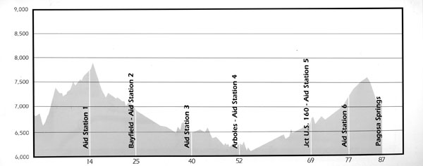 It’s 62 miles from Durango to
Pagosa Springs as the car drives on
US 160, but the race organizers selected a more “scenic” 87-mile route that led us toward
(but not actually to) Lemon Reservoir and Vallicito on County Road 240 before turning south on County
Road 501 to Bayfield. This alternative “long cut” to Bayfield was in fact a lovely ride
through cool shaded farming areas: not much traffic, and after an initial grade for the first 15 miles,
the road gave way to a long downhill through Bayfield, across US 160 and, with a few short hills along
the way, continued south to Arboles near
Navajo
Lake State Park and the New Mexico border. From there, the next 17 miles on State Route 151 was very
hot, open (i.e., no shade), and uphill to the junction of US 160. With temperatures over 100°, some of
us bordered on dehydration in spite of gallons of water, fruit smoothies, and Gatorade. I poured water
over my head every chance I could. By the time I reached the rest stop near
Chimney Rock and US 160 I felt truly
exhausted. My strength was sapped. After a half hour rest and lots of liquid, I was just able to finish
the last 20 miles into Pagosa. Any farther would have been problematic.
It’s 62 miles from Durango to
Pagosa Springs as the car drives on
US 160, but the race organizers selected a more “scenic” 87-mile route that led us toward
(but not actually to) Lemon Reservoir and Vallicito on County Road 240 before turning south on County
Road 501 to Bayfield. This alternative “long cut” to Bayfield was in fact a lovely ride
through cool shaded farming areas: not much traffic, and after an initial grade for the first 15 miles,
the road gave way to a long downhill through Bayfield, across US 160 and, with a few short hills along
the way, continued south to Arboles near
Navajo
Lake State Park and the New Mexico border. From there, the next 17 miles on State Route 151 was very
hot, open (i.e., no shade), and uphill to the junction of US 160. With temperatures over 100°, some of
us bordered on dehydration in spite of gallons of water, fruit smoothies, and Gatorade. I poured water
over my head every chance I could. By the time I reached the rest stop near
Chimney Rock and US 160 I felt truly
exhausted. My strength was sapped. After a half hour rest and lots of liquid, I was just able to finish
the last 20 miles into Pagosa. Any farther would have been problematic.
It turned out to be the most difficult and most challenging day of the entire week.
The sag wagons and staff cars were filled with riders even before noon, their bikes on top, headed
to Pagosa. I have no data nor did I hear any stories, but it
 would not surprise me that hundreds of riders suffered some degree of heat exhaustion or full blown
dehydration and sought alternative means to reach the stopover in Pagosa.
would not surprise me that hundreds of riders suffered some degree of heat exhaustion or full blown
dehydration and sought alternative means to reach the stopover in Pagosa.
The heat of the day was compounded by my speed, or lack of it. I left Durango about
6:15 and finished at 3:00. I made pretty good time until I reached Arboles at noon—52 miles in
just under six hours including rest stops. (Don’s advice: stop at every rest stop whether you
think you need to or not.) I was just 35 miles from Pagosa. If I had been an hour faster, or left an
hour earlier, I would have missed an hour of the most oppressive heat of the mid-afternoon. It would
still have been a struggle, but without as much pain.
When I got to Pagosa, I looked for a tent site not on the football field and wound up
on a sloped lawn area, but in the shade. As I sat waiting for my 5:30 massage, I watched hundreds of
folks coming and going—heading to the showers, to the hot springs, to dinner, getting their tents
set up, resting, talking on their cell phones, etc. Lots of people walked much slower than yesterday;
quite a few limped slightly or were bent over—not so much spring in their step. There was a lot
of talk about today’s ride. On the shuttle bus to town this evening the guy sitting next to me,
who had done several RTR in the past, said today’s ride was one of the three hardest he’d
ridden. He also said the thermometer on his bike never registered below 99°!
Kevin gave me a half hour massage on my legs only. He worked a lot on getting the knots
out of my quads and calves. When I stepped off the table I collapsed with cramps in both legs. The
consensus of the massage folks is that I was dehydrated in spite of lots of liquid intake. On the
other hand, I think I was only near-dehydrated: I didn’t have nausea, didn’t have
a headache, and hadn’t felt lightheaded. I also only peed once all day, a pretty reliable sign
I was dehydrating. I also hadn’t eaten—I just didn’t feel hungry. I was advised, in
the future, to drink more water than I had: four pints of water for every pint of Gatorade. I did have
a pasta dinner and, later, a mediocre milkshake at the only place in town that makes them.
I was really tired as I headed for bed, but I felt rejuvenated from eating and walking
through town. I was also very sleepy, so at 9:15 I was in my bag and read myself to sleep.
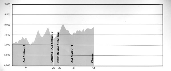
RTR Day 3: June 20 •Pagosa
Springs to Chama, NM: 50 miles, 3200' elevation gain
By 3:00 this afternoon I’d had a shower, pitched my tent, ate some lunch, and
walked from the elementary school in Chama
to Foster’s 1881 Hotel and
Saloon on the main street. It’s right across from the train yards that are home to the
Cumbres & Toltec Scenic Railroad. I
sat outside the bar drinking gin and tonics under a patio roof that provides great shade and a cooling
breeze to go with the view of stragglers still finishing the last of the 50 miles from Pagosa Springs.
The big crowd was inside watching a World Cup match and fussing with the lone bartender who was
working like crazy to keep up with the requests shouted her way. I began my log as a soaked up the
shade and breeze.
Today was our second short day, a “restful” ride that was not particularly
scenic, though lots of groups stopped for a photo at the state line. The route was over the rolling hills
of US 84 from Pagosa Springs through Chromo (Colorado)—blink and you’ll miss it—and
miles of scrub brush. We had three or four long grades, none of which was severe. Maybe I’m getting
stronger each day as Don said I would. It took me four hours to finish this section of the ride, but I
stopped for at least an hour at the three rest stops, eating and drinking a bit each time and resting. I
felt no rush.
Chama was a very welcoming city. Our arrival in town provided the residents some
diversion, maybe even excitement in this isolated ranching community of just over 1,000 folks. Kids
and adults stood outside their homes as we approached town waving American flags and shouting hello.
The local radio station gave away New Mexico yellow and red souvenir T-shirts commemorating the race
route. I should have gotten one.
The food stands set up in the school yard by local groups (churches, the school, Lions
Club, etc.) offered terrific homemade specialties: for lunch I found an outstanding vegetarian bean soup
that not only was tasty and healthy, but made with hominy along with different kinds of beans—$5
for all I could eat, and I had found my appetite. I also found a comfortable place to eat: a real chair
and a real table in real shade of real trees (in dry climates shade makes all the difference), all of
which were in slight supply in the other towns.
After I set up my tent and had a shower, I had my second massage: a half hour on my
upper body only. After yesterday’s crippling session with Kevin, I hoped I wouldn’t wind
up with a dislocated shoulder. Afterwards, I sat along an irrigation canal that ran behind the school
grounds and soaked by legs in the cold water along with a dozen other folks who had the same idea.
I caught up with Mark today and we decided we should take advantage of the railroad’s
offer of an “introductory” ride on the
Cumbres & Toltec RR.
The hour-long ride took us toward Cumbres Pass which we would ride over in the morning. The docent/guide on
the train gave us a lot of the history of the railroad and sights along the way. If the purpose was to entice
us to return to take the full 64-mile trip to Antonito (Colorado), they got my interest. I’d like to
come back for the great camping above town as well as the train ride which in the fall takes passengers through
miles of aspen (the third week in September, our guide said, was usually the peak time of the year).
Our guide also recommended Patsy’s as having the best Mexican food
in this predominately Hispanic town. In fact, Patsy’s specialty is a
Navajo taco, which I haven’t
had since we last stopped at the Tuba City (Arizona) Truck Stop. Mark and I agreed to meet there
about 7:30. The waitress and cook extended their closing time beyond 8:00 p.m. to let in Mark who
was a few minutes late. Patsy’s is a real family place: they don’t serve booze, there
are lots of kids were there with moms and dads, and the staff was home town friendly.
As I write this in my tent before dipping into my paperback mystery that does the work
of any sleeping pill, I want to remember three things I should have brought with me:
1. A phone card
(I’ve got one with hundreds of minutes on it and I just blew it off!);
2. A small pillow
(with a pillowcase so that my head is more comfortable than it is resting
on a lightweight jacket that I never used and my face grease doesn’t soil
either the jacket or my sleeping bag); and
3. A camera
(What a doofus! I’ve never gone off on a trip without a camera. Photo ops
have been everywhere: lines of riders strung out on the highways, great scenery,
tent cities, the folks I’d met and would like to remember. I’ll never have
a chance to take a picture of a million dollars worth of bicycles in a fenced
security area. Where was my head??)
Day 4: June 21 •Chama
to Alamosa: 83 miles, 3200' elevation gain
 The route profile on the left for this day shows a fairly
steep ascent: Cumbres Pass is rated at 6.3% for the first 12 miles, and
the next 7 miles to the summit of La Manga is rated at 5.2%. The second pass
is followed by 64 miles of continuous descent into Alamosa. If I could make
it to the top La Manga I knew I would be home free for the rest of the trip:
the next two days were generally flat or downhill (or so I thought).
The route profile on the left for this day shows a fairly
steep ascent: Cumbres Pass is rated at 6.3% for the first 12 miles, and
the next 7 miles to the summit of La Manga is rated at 5.2%. The second pass
is followed by 64 miles of continuous descent into Alamosa. If I could make
it to the top La Manga I knew I would be home free for the rest of the trip:
the next two days were generally flat or downhill (or so I thought).
I stopped at the first rest area after 8 miles on
the slopes of Cumbres Pass. I was actually feeling pretty strong still.
I didn’t exactly race up the hill, but my pace was steady. The views were
beautiful, especially looking back at the hundreds of bicycles that followed
me up the road. The weather was fantastic: clear skies, cool temperatures,
and the wind at our backs. We could not have asked for more.
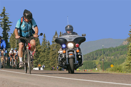
As I neared the summit, the official race photographer,
Martyn Warwick of MW Photography
in Albuquerque, was waiting for us to reach the top for individual action
photos. Just as he took my picture one of the state troopers, who provided
safety for us the entire route, pulled very close alongside me. I was startled
and yelled out, “What the hell are you doing?” He yelled back, “I’m getting
my picture taken. Whaddaya think?” Or something like that. He laughed and rode on.
 Some folks who saw it convinced me I could get a good story or two out of it. So here it is.
The descent was quite a ride. I hit speeds of over 40 mph for the 17 miles down to
Fox Creek, a beautiful area of the state I’ve never been to but will go back to soon. State
Route 17 follows the sparkling flow of the Conejos River with great camping and newer vacation
homes along the banks. The area is jammed with campgrounds, good fishing, scenic hikes I’m
sure in healthy forests of spruce, pine, and aspen.
The tall trees gradually disappeared after Fox Creek and we entered the San Luis Valley.
We had rest stops in Antonito
(a wonderful Visitors Center, worth the stop anytime),
Manassa (it’s
hard to believe that heavyweight champ Jack Dempsey came from here), and
Sanford
(the sweetest tasting water on the Ride came out of a hose at the fire station).
By this time it was late in the morning and the sun was growing stronger.
It was only 17 miles from Sanford to Alamosa
and while the roads were flat, generally free of traffic, and paved though
not always smooth, this was a section just to get through to reach a shower,
a place to have dinner, and grass on which to pitch my tent. I was doing
pretty well with this mindless plan, until I had my first and only flat tire
of the trip at a crossroads in middle of nowhere: the valve stem was cracked and
the air virtually exploded as I started to make a left hand turn. There was
nobody in sight except for a guy selling lemonade out of his VW van. What
joy! I put in a spare inner tube, had a glass of ice cold fresh squeezed
lemonade, and rested in the shade of his tarp which he had attached to the
side of his bus while we chatted a while. When I was ready, I finished the
last 10 miles into Alamosa.
Heidi (from Nederland) and her friend, Sarah, had caught up with me at Antonito,
but when we took off together from Antonito, they left me in the dust. Young legs. I haven’t
seen “Fast Mark” all day. He probably passed me on the hills and just kept going.
Oh, well. It’s not a race. It’s not a race. It’s not a race.
I finished the 87 miles in about eight hours, which included nearly two hours in rest
stops and the stop to fix my flat tire. I’m not ready for the Tour of France (Aren’t they
incredible riders!!), but I didn’t shame myself either.
I had dinner by myself at True Grits, a steakhouse with a John Wayne theme on the north
side of Alamosa best known for its thick steaks. I really wanted a fish dinner, but the shuttle bus
driver recommended the restaurant so highly I got off with several other folks. To my delight, fresh
Atlantic salmon was featured on the menu and it was delicious! What a great choice.
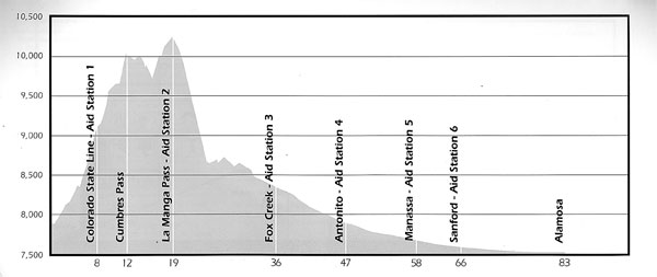
RTR Day 5: June 22 •Alamosa
to Salida: 84 miles, 1600' elevation gain (most of it over Poncha Pass)
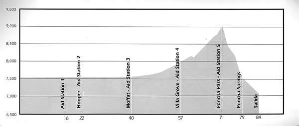
I wrote this entry in the afternoon while sitting in the shade at
Salida City Park. I soaked my feet up to
my knees in the Arkansas River that flows through town. After 90 miles of riding today the water and
the shade are a blessing. Tomorrow will be downhill to
Canyon City, except for a side
trip to cross over the Royal Gorge Bridge.
I started early at about 6:00 a.m. to avoid as much San Luis Valley heat as possible.
We were blessed with a west to southwest wind most of the day and some clouds to keep the heat down.
Most of the road (the first 57 miles of SR 17 from Alamosa to Villa Grove) is flat, the scenery dull,
and road bumps every 10'–15' from tar-filled cracks in the surface. You wouldn’t
notice them in a car, but after five days of sitting on a bike seat, every crack sends a shock of pain
up your back.
We took brief stops in Mosca and Hooper (hardly specks on the most maps) for water and
a quick stretch. But at
Moffat we were
treated by the entire town (there are only 150 or so residents and it seemed like they were all there)
who showed up to bake a couple of thousand locally
grown potatoes which were free with all the fixings (bacon, sour cream, butter, and/or grated cheese).
Delicious. I cannot ever buy Idaho spuds again after tasting these Colorado goldens. We sat at real picnic
benches under real trees that made real shade.
Note: If I appear to keep dwelling on these small items
(shade, tables, etc.), it’s because there were precious few opportunities to really rest during the
Ride in shady areas sitting on something halfway comfortable. Usually, we stood in a dusty, rocky area
(parking lot or pull out) on the side of the highway with no protection from the heat. Poor planning,
or simply the circumstances of this particular route?
Our stop at Villa Grove was highlighted by the only raindrops of the trip: a fast traveling
cell moved in and out of the area in about five minutes, just enough to settle the dust but not enough
to create backsplash conditions on the road.
The ascent over Poncha Pass (less than 3% grade) was mild, though a bit longer than I had
remembered from previous trips. I skipped the aid station at the top of the pass, knowing we’d have
a steep descent just ahead: a 40+ mph screaming 8-mile ride down into Poncha Springs, with Salida another
gentle five miles away.
I set up my tent on the thick grass of the Salida High School football field (no shade of
course) and added a precautionary rain fly, though I took it down later in the evening as the cloudiness
disappeared. I took a long shower in the guys’ shower truck (one for the guys and one for the women,
each with six showers on each side and no shortage of hot water). I changed into town clothes and biked
into Salida for an iced mocha latte, browsed through a local bookstore, and got $40 at the ATM.
Note: Salida has received a lot of good publicity in
recent years as one of Colorado’s “coming” towns: lots of galleries and artists, cute
shops, kayaking and rafting on the Arkansas River, a friendly climate, and high quality of life. In short,
a good place to live. Perhaps it is, though the new houses are being built away from town, leaving small
though tidy bungalows inside the city limits. The tall trees are not near town and aside from the city
park and a few attractive shops, I didn’t find a lot to recommend it as highly as its reputation.
I had hoped to find Mark for a last dinner together, but we never were able
 to connect. I wound up sharing a table with another biker who also had no dinner companion. The meal at
Laughing Ladies was outstanding—great pepper steak and marvelous bread pudding
for dessert.
to connect. I wound up sharing a table with another biker who also had no dinner companion. The meal at
Laughing Ladies was outstanding—great pepper steak and marvelous bread pudding
for dessert.
Some thoughts on this final evening:
•In spite of heat, irregular eating, a shameful training effort, and working hard every
day, I feel fine. I am pooped at the end of each day (sometimes sooner), but after a shower and bit of
walking around I seem to recover quickly. Each day I’ve felt a little stronger in the evening.
•The flat stretch of road today seemed littered with flat tires or tire-related
problems causing lots of riders to stop. The sag wagons were busy with individuals or their bikes, like
Day 2, which were apparently not up to the heat. I learned there was a fairly serious collision among
several riders who were in a long drafting line today; one of the guys in the line who escaped
crashing said the front two or three bikes “suddenly were perpendicular to the road,” and
the next three or four riders could not avoid crashing into them.
•Worst of all, in the evening we learned that late in the day one rider, a
64-year-old woman from Boulder, was killed when she accidentally collided with an RV as both were pulling
away from a stop sign in Salida. Accidents with bikes, as with most things, happen in a split second of
carelessness, inattention, or bad judgment. Bike riders are generally more vulnerable than others. I feel
fortunate that I’ve come away with nothing more than a flat tire.
•I seem to prefer biking like I run: by myself. I am quick to move to the right
when folks want to pass (that’s most of the riders). It’s tougher biking as a single rider,
but I’m free from the distractions of nearby riders. The same folks who love to talk throughout
a 5K or 10K run probably like to talk to each other when they bike. Not me. Talk to me when we stop at
a rest area or over dinner, but on the road, leave me alone.
•Pithy sayings or words of encouragement had been spray painted on the pavement
all along the route from Cortez onward, things like “Move our ass over Poncha Pass,”
“Pain is the body’s release of weakness,” or “Live life today.” One of
the messages today said something in praise of the person who invented the bicycle. I’m sure I
was not alone in suggesting shooting the guy who designed the bicycle seat. There must
be a way to prevent the pain of a raw crotch or bone bruises on the buttocks. Yes, I know there’s
also some muscular aches and pains, but I’m talking about hurt where it really hurts.
I also heard a few women complaining that the seats “specially designed” for women don’t
work either. Whoever comes up with a solution can make their fortune.
RTR Day 6: June 23 •Salida
to Canon City: 67 miles, 3200' elevation gain
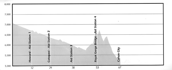 Canon City at last. The Ride is over. I’d be less than honest if I didn’t
acknowledge a huge relief along with a great sense of accomplishment. When I sent my money in last
February, I really wasn’t certain I could do it. Now I know I can ride anything Colorado can
throw at me.
Canon City at last. The Ride is over. I’d be less than honest if I didn’t
acknowledge a huge relief along with a great sense of accomplishment. When I sent my money in last
February, I really wasn’t certain I could do it. Now I know I can ride anything Colorado can
throw at me.
Today’s ride was a gradual descent on US 50 along the Arkansas River for about
45 miles—a gift of the Ride organizers. Weary or not, downhills are always better than the grind
of even a 1% grade. What a joy!
We turned off to the
Royal Gorge Bridge, approaching from
the south on the little used road with less traffic (see photo above). The road surface hadn’t
received much maintenance and the last three miles were steeper than we’d faced all week. I met
Mark on the way up; as he blew by me, we agreed to meet at the bridge and ride into Canon City together.
Walking our bikes over the bridge was a memorable way to finish the Ride. We watched a
train 1,053' below us alongside the Arkansas River as it passed a group of rafts going in the same
direction. We also watched a helicopter make several passes down into the gorge, though not under the bridge
itself. We joined hundreds (thousands?) of folks walking (most with their bikes) across the 1,260-foot long
span. Everyone was in a festive mood because we knew that Canon City was a mere 12 miles away.
The park in Canon City provided sweet relief from the heat for the finishers. Some cold
beer and a Polish sausage were a perfect lunch and I had my final smoothie for dessert. I changed clothes,
repacked my duffle and put it on the return bus. I broke down my bike, packed it in its cardboard box and
stowed it in the truck for delivery to the parking lot in Golden where we began the trip. After closing
“ceremonies” and a raffle for some really good schwag, I boarded the bus for the return trip
home.
REFLECTIONS ON THE BUS RIDE HOME
I’m tired but overall OK. No aches or pains or blisters. I got a lot of sun,
I slept well and, except for Day 2 (the very hot one), I ate well. I stayed healthy and I leave
feeling a little stronger than when I began. I lost only 2-3 pounds for all the exercise I had.
I’ve always been impressed that Judy has run several marathons and in good times.
I’m still trying to decide how riding a bike 419 miles in six days compares with running 26 miles
in three and a half hours. Neither of us can be certain since neither of us has done both. (Don Hayes,
who has completed several marathons and four Ride the Rockies, is of the opinion that marathons are
more difficult, more challenging. He’s probably right.)
My bike is like our former mini-motorhome: underpowered and overweight. When I was helping
to unload bikes off the truck at the end of the return trip home, I discovered my bike box weighed at
least twice what the others weighed. Add my weight to that of the bike (plus the kick stand and the mirror)
and you realize it takes a lot of leg power to get both the bike and me up the hills.
While I’m glad I signed up for the Ride, I’ll probably not do it again.
I proved to myself I could, but I didn’t find it exciting nor particularly interesting aside
from accomplishing what I set out to do. Doug Bradbury, a hall of fame mountain biker from California,
said it best in the Boulder newspaper this week (Daily Camera, July 26, p. 8C):
“The best rides are the ones where you bite
off much more than you can chew—and live through it.”
This was my best ride. I lived through it, and I earned bragging rights for at least a year.
