COLORADO–UTAH ROAD TRIP
AUGUST 10–25, 2014
BIG PICTURE
We packed a lot of scenery, history, and adventure
into our two weeks on the road!
We drove our RV and towed the Rav4 from Nederland to
Marble, Colorado for two nights, through Ridgeway for one night, and on
to Bluff, Utah for three nights and Escalante for two nights, before
reaching Kanab, Utah, our final destination. Along the way, we visited
the hard-to-reach ghost town of Crystal, Colorado, toured Monument
Valley Navajo Tribal Park, discovered sites inhabited by the Ancient
Ones along Montezuma Creek east of Blanding (Utah), crossed the bridge
at Hell’s Backbone near Boulder (Utah), drove a good portion of the
Hole-in-the-Rock Road out of Escalante (Utah), settled in Kanab (Utah)
to volunteer at Best Friends Animal Sanctuary and, for a short while,
enjoy the festivities at the 16th annual Western Legends Roundup. Our
return home was a two-day sprint across Utah and Colorado on I-70.
MARBLE
AND CRYSTAL (COLORADO)
Our first stop was Marble,
Colorado, just south of
Glenwood Springs and Carbondale. It was not very long ago that Marble
was on its way to becoming another Rocky Mountain ghost town. The town
is named after the high quality marble from the Yule
Marble Quarry that
was used in the construction of Lincoln Memorial, Tomb of the Unknowns,
other buildings across the country. The quarry came to life in the late
19th century, but the high cost of extraction and transportation caused
a decline in the mine and with it a similar decline in population.
Today, the mine has been purchased by an Italian company (from Carrera)
and in spite
of high transportation costs, the marble is still valued and selling
well throughout the world as well as in this country. There is a
renewed interest in the town in the past decade, with folks realizing
how beautiful the area is (and always has been). Visitors (like us) who
haven’t been to Marble in twenty or more years will be surprised at the
new (and expensive) houses that have sprung up on the outskirts of the
town and the active restoration of older buildings in town, several of
which are on the National Register of Historic Places.
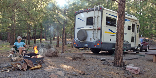
At the north end of town Bogan
Flats is a very
comfortable and scenic 35-site campground national forest facility
located on the Crystal River. We arrived in the late afternoon without
a reservation. Next time we’ll reserve ahead and try for sites 21, 24,
or 25 along the river, though our site was just fine.
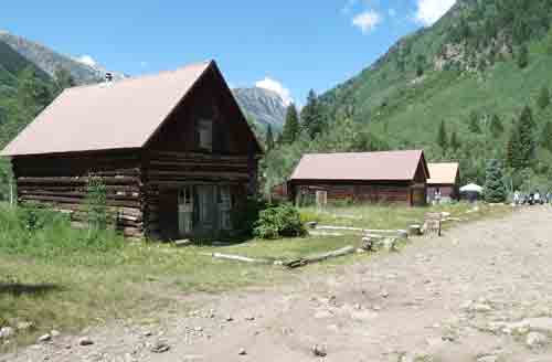
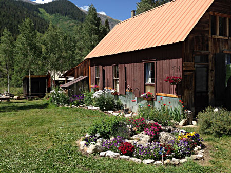
However, it was the ghost town of Crystal, six
miles
south of Marble that drew us to the area (see photo above of the
current Main Street of Crystal). We have visited quite of few
Colorado ghosts, as well as others throughout the Rockies, but Crystal
has always held a kind of fascination because of its remote location
and the challenging road in and out, portions of which are often
described as “not for the faint of heart.” Crystal is also the site of
one of the state’s most photographed images, the iconic Crystal Mill
that graces scores of calendars every year.
We could have hired a jeep, motorcycle, mountain
bike, or ATV to make the trip; we could have gone with a local tour
group that brings visitors from Marble to Crystal twice a day; of
course we could have hiked the 12-mile round trip. In the end we
decided that our 4-wheel drive Toyota Rav4 could make the trip without
much difficulty. After all, we have navigated some pretty rough, rocky
roads right here in the Nederland area.
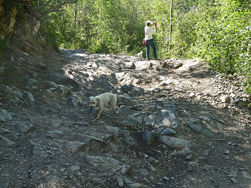
We pretty nearly made it all the way to Crystal and
would have gone all the way except for one short, steep, treacherous
ten yards of bare rock about halfway there that likely would have
restructured the bottom of our semi-high clearance vehicle. As a result
of our caution we prudently decided to park the car on the side of the
road and hiked the remaining three miles to Crystal. The dogs (Lucy and
Bella) enjoyed the adventure to the town site, and we arrived somewhat
surprised to meet many of the summer residents who arrived in jeeps,
pickups, on ATVs, as well as visitors on motorcycles and mountain
bikes. (The three guys on mountain bikes came the hard way: they rode
north on Forest Road 317, sometimes called “the Gothic Road,” from
Crested Butte through the ghost town of Gothic, and across the
extremely difficult and notorious Schofield
Pass, traversing the
Devils Punchbowls, considered among the most dangerous drives in the
state.) There was one “car” in town: a late model Subaru Forester that
brought a family comfortably up from Marble. We were very impressed!
If the journey to Crystal was memorable—and it
was—the remains of the old mining town itself left a lasting impression
on us as well. A dozen or so well maintained cabins sit in a fairly
flat area dotted with aspens. Lawns are watered and mowed, the flower
gardens are spectacular, the path to the public outhouse is tidy, and
there’s no traffic to keep visitors from walking down the main street
in town. You can purchase sodas and water, along with post cards
and souvenir T-shirts at a small general store; some cabins are
available to rent; there is a bookstore run by author Roger Neal, whose
book Crystal…What
Really Happened (Crystal Tale Books, Elkhart,
Indiana: 3rd edition, 2005) is a well documented and interesting
history of the people and the mines of this fabled town high up in the
Rocky Mountains. And the author was there to autograph a copy.
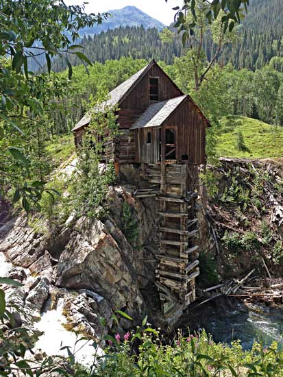
Just a few hundreds yards to the north of town is
the Crystal Mill
(referred to as the “Old Mill” by historian Roger
Neal; originally called the Sheep Mountain Power House; other sources
identify it as the Lost Horse Mill or the Dead Horse Mill)
sitting high above the waters of the Crystal River. This frequently
photographed structure, built in 1893, housed a vertical axle that
drove a horizontal wooden wheel that powered an air compressor, which
pumped air to drills in two different mines. (Contrary to some
accounts, Crystal never had electricity and it still does not.) The
current owners of the mill continue to work on its restoration.
On our hike back to where we left the car, the dogs
went from one shaded area to the next, stopping occasionally to drink
heavily from the clear waters of the Crystal River. We drove the rest
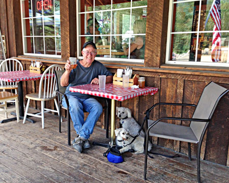
of the way back to Marble and had the best meal of the entire trip at
Slow
Groovin’ BBQ (read our review at Trip Advisor). The beef brisket
and the salmon filet, both taken
fresh from the smoker next to the porch, were to die for, the beer was
cold, the blueberry pie was fresh make, the front porch provided shade,
and the dogs drank and slept under the table while we enjoyed some of
the best food anywhere between Denver and LA. It was a perfect end to a
remarkable day.
RIDGEWAY
(COLORADO) STATE PARK
Back in the 1970s and ‘80s, we regularly drove out
from Ohio to spend almost every summer working on our cabin in
Silverton and exploring that area of the San Juan Mountains in
southwest Colorado. At that time Ridgeway was a quiet crossroads we
drove quickly through between Montrose and Ouray before we climbed over
Red Mountain Pass to drop down into Silverton. In 1987 the Department
of Reclamation completed the Ridgeway Dam across the Uncompahgre River,
creating a reservoir to control the flow of the river and developing a
recreational facility for boating, fishing, swimming, camping, and
hiking.
We stayed at Pa-Co-Chu-Pak
campground, one of the
three camping areas within the park north of town where there are full
hook-ups for RVs, trailers, and areas for tents. (User fees are fairly
consistent throughout the state park system: $7 daily per vehicle plus
$26 for full hook-up sites. There is a $10 reservation fee. For other
fee options check the state park web site at cpw.state.co.us)
In
addition to camping, there is access to several miles of bike/hike
trails. The Uncompahgre River Trail bike path parallels the highway (US
550) connecting the state park campgrounds to the town of Ridgeway.
Though paved, this is only a small portion of over 40 miles of both
paved and single-track trails in the Ridgeway area. We spent a very
pleasant couple of hours on a morning ride before continuing our
travels into Utah.
BLUFF
(UTAH)
Driving west of Ridgeway to the Utah border took us
across the Dallas Divide, an area of aspen hillsides whose expanse of
autumn colors are often featured on Colorado calendars, and down
through the beautiful canyon of the San Miguel River to Norwood where
the landscape flattens out and ranches spread for miles, all the way to
Utah where Abajo Peak stands tall in the distance at over 11,000' We
turned south at Monticello (pronounced locally as Monti-sello), through
Blanding (where many of the early settlers in Bluff moved when they
found they could not control the San Juan River flooding and gave up
farming and turned to ranching in the Blanding area), and finally to
Bluff.
The history of Bluff is a testament to human
struggles against incredible forces of nature and the will to survive.
In 1879 a group of Mormons (mostly family groups) living in the western
part of the state volunteered to travel across the rugged and largely
unexplored central part of Utah to the portion of the state south of
the Colorado River where only a few Paiutes, Navajos, and gold-seekers
had settled. They came with their families and only what possessions
they could carry on their wagons. In the fall of 1879 they met up in
Escalante to form the San Juan Mission. Several alternative routes to
Montezuma Fort, less than 200 miles away near the Colorado border were
discussed. Eventually they chose the most direct route: straight to the
Colorado River 60 miles from Escalante, and across the river close to
where it is joined by the San Juan River. Montezuma Fort was less than
100 miles from the crossing. However, when the families faced the 1500'
descent down to the river, the trip took on an epic challenge at the
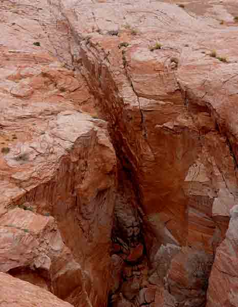
now famous Hole-in-the-Rock.
They built a “road” down a crack in the
face of the cliff so the wagons could be driven to the river and
animals could be lowered by ropes. After they built rafts to cross the
river and then pulled themselves up the other side, they faced new
hardships: fierce winter snows, little firewood, treacherous landscapes
that required more road building, and declining food and water
supplies. By April of 1880, they gathered at a flat area near the
confluence of Cottonwood Wash and the San Juan River and decided they
had gone far enough, though Montezuma Fort was only 20 miles beyond.
Bluff City, as they named it, became their new home. A six-week journey
had turned into a six-month test of will and determination.
This story is central to the ethos of Bluff and of
the people who live in San Juan County. The story is told throughout
the state; re-enactments are held; descendants of those first pioneers
gather on occasions to climb down and back up the Hole-in-the-Rock and
relive the memory of the courage and determination of their 19th
century ancestors. It’s a remarkable story for which there is a good
deal of documentation, especially from journals and diaries kept by the
pioneers. David Miller’s Hole-in-the-Rock: An
Epic in the Colonization
of the Great American West (Salt Lake City: Un. of Utah Press,
1966) is
considered the most complete history of this event. Stewart Aitchison’s
A Guide to
Southern Utah’s Hole in the Rock Trail (Salt Lake City: Un.
of Utah Press, 2005) offers a brief, authoritative overview of the
journey including references to contemporary roads and locations for
those who might attempt to retrace the trip.
[While
we were in Bluff we attended a lively
performance of “Hole in the Rock Honeymoon” written, narrated, and sung
by the Home Town Harmony Singers from Blanding and based upon
historical anecdotes and journals. This non-professional production,
was presented at Bluff Fort, a reconstruction of original cabins and
tools, as well as the home of the Hole-in-the-Rock Foundation.]
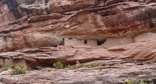
•Montezuma
Canyon
One of our primary reasons for returning to Bluff
was to explore the archeological sites along Montezuma
Canyon. This
rugged and isolated region was carved out by Montezuma Creek that goes
between Bluff and Monticello about 15 miles to the east of US 191. We
began by driving 14 miles north of Bluff to the paved road to Hatch
Trading Post and Hovenweep
National Monument beyond. In 15 miles we
left the pavement at the Hatch Trading Post and turned north on county
road 146, a well graded gravel road. The next 36 miles is a lonely
stretch of road (no services, no water, no cell service, no traffic—we
were by ourselves virtually all the way) where the walls of the canyon
show evidence of the Ancient Ones (formerly referred to Anasazi) who
settled in the area over 1,000 years ago. They left petroglyphs, kivas,
granaries, and other signs of life. Thanks to a Nederland neighbor, who
visited the area some years ago, we had a mile-by-mile guide to many of
these sites.
Along the way, we saw a few signs of modern
settlers: corrals and stockades along the road where free ranging
cattle might be rounded up and held for transport; huge bales of hay
are stored in natural caves in the Navajo sandstone that makes up the
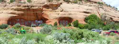
landscape; a handful of ranches are located here and there on the
northern section of the road; two or three folks have built
conventional walls (with doors, windows, etc.) on the faces of natural
caves in which they appear to live; and an oil company (maybe more than
one?) have wells and tanks scattered throughout the area.
We drove the road with confidence until we came to a
creek crossing that we declined to cross, even with 4-wheel drive. The
water was flowing quickly from a recent storm runoff, we didn’t know
how deep the water was, and it was a pretty wide crossing. We didn’t
see any tire tracks on the other side. So we backtracked a few miles to
reach a parallel road that would take us around the risky creek. We
returned to the canyon bottom via Deadman Canyon Road, a steep, narrow,
twisting, not very well graded downhill track worthy of its name that
brought us back to the good gravel road, but on the other side of the
creek. We caught our breath and continued on our way, only to encounter
two or three more creek crossings. These, however, were more like long
puddles, not flowing water and not quite as wide as the first one, and
the thought of going up Deadman Canyon was not a cheerful option. So we
held our breath and drove across without much more than muddy, wet
tires. The first time was the hardest; the next time we didn’t
hesitate.
[We
did not have a sufficient map to pinpoint where
we were on the canyon road 146. When we got to the junction of Deadman
Canyon Road and county road 146, we turned north to continue in the
direction of where we had been heading. As a result, we missed the star
attraction of the canyon, which was a few miles to the south: Three
Kiva Pueblo. This apparently is an excavated site consisting of a
14-room complex that is open to careful exploration by the public. A
booklet published by the BLM and the Canyonlands Natural History
Association is guide to locating and explaining this historical site.
We’ll have to go back, but not during the rainy season.]
By mid-afternoon the storm clouds were thickening
and we were glad to be heading up out of the canyon back to the
pavement (US 191) just as the downpour began.
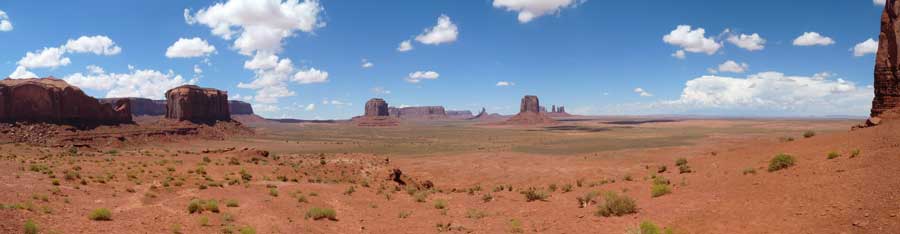
•Monument
Valley Navajo Tribal Park
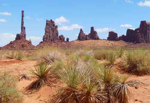
John Ford and John Wayne made Americans aware of
this remarkable and enchanting area on the border between Utah and
Arizona. As often as we have driven by this beautiful area in
previous trips, we have never driven through the park. We have had such
good experiences in the past with native guided trips at other Navajo
owned parks (Canyon
de Chelly and Antelope
Canyon) we decided to find a
guide who would not only take us but also the dogs, who we couldn’t
leave for the day. Without a reservation, we stopped at the visitor
center booth where various individuals and companies are located. We
simply asked if there was a driver or company who would take us and
Bella and Lucy on a tour. There was some hesitation and finally one
person spoke up and said she’d take us. No extra charge for the dogs
and we would be the only passengers on the trip. It turned out that our
driver was Ryan Holiday, a very friendly and accommodating (and soon
to be father) young Navajo who was our driver and our guide for the
four-hour trip (it was advertised as a two and a half hour tour, but we
lingered at some stops). Ryan knew the names of all the formations, the
locations of various movies or scenes of movies were filmed, where to
stop for special photos, where to stop for refreshments, and knew where
legendary weaver Susie
Yazzie’s hogan is, though she had sadly passed
away in February, 2013 at the age of 93. We’re sorry we missed the
opportunity to meet this remarkable and beloved woman. Her daughter or
grand-daughter (?) now greets visitors instead and describes the
process of taking the sheep’s wool and turning it into beautiful rugs
in the tradition of Susie Yazzie. (This meeting is only available with
a guide and was itself worth price of the tour.) Still, Ryan knew his
way around the sandy road system within the park and drove the vehicle
with courage and confidence.
[Our
advice: Take the tour. You’ll get so much more
out of your time in the park. Your car will thank you, your passengers
will thank you, and you’ll meet friendly and interesting people you’d
otherwise miss.]
On our return, we stopped by the Cow Canyon Trading
Post on the north edge of town where Liza Doran used to prepare
outstanding gourmet meals worth driving out of our way to enjoy.
However, she has given up that part of the business and instead is
concentrating on promoting the works of Native artists: jewelry makers,
Navajo weavers, fine photography and graphics, and, more lately,
paintings on wood based upon ye’ii images by Navajo artist Thomas
Begay. We added one of his remarkable and unique creations to our
collection of other Native American works.
We toured Bluff
Fort, bagged about a dozen geocaches
in the town and area, packed up and prepared to leave Bluff in the
morning.
DRIVING
UTAH’S ROUTE 12
Utah State Highway
12 is one of the most scenic drives in America, an extraordinary
experience that offers visitors nearly the full range of geologic
landscapes the state has to offer. This designated National Scenic
Byway begins in Torrey on the west side of Capitol Reef National Park
and travels 124 miles south and west where it ends at the junction of
US 89 (also a scenic drive). Along the way it passes through the
conifer and aspen groves of Dixie National Forest (9,636' at the
summit), down through the cattle ranching towns of Boulder, Escalante,
and Tropic, and through the red sandstone cliffs of Red Canyon on the
north edge of Bryce National Park. Inviting side trips include the Burr
Trail (leaving from Boulder), Hell’s
Backbone Scenic
Backway (accessed from either Boulder or Escalante), the
Hole-in-the-Rock
Scenic Backway (starting in Escalante), and Cottonwood
Canyon Scenic Backway and Kodachrome
Basin State Park (out of
Cannonville). All are graded gravel roads, passable by regular cars
except following rains. This is a remarkable area of the state and
country, one that visitors should include in their travel plans.
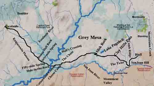
To get to Torrey from Bluff, we drove through a
desolate section of south-central Utah, much of which the
Hole-in-the-Rock pioneers traveled: north through Butler Wash, across
Comb Ridge, through the Grand Gulch Primitive Area and the Red Rock
Plateau to Hite Crossing on the Colorado River at the bottom of Glen
Canyon.
The outside temperature began to rise, as did the RV’s engine as we
climbed up from the river and skirted the Henry Mountains on our way to
Hanksville
(in the middle of nowhere). From there we turned west to
Capitol Reef National Park and down into the green grass and shade
trees of Torrey and Wonderland RV Park. In the morning, we bicycled
south on SR 12 as far as Grover then returned, showered, and moved on
by late morning.
We drove south 15-20 miles until we reached Pleasant
Creek Campground, a national forest facility that was deserted
(though
the rest rooms were open, clean, with plenty of TP). We hadn’t planned
to stay there—in fact, Judy would have bicycled there if we had planned
better. We saw this as chance for some rest and recovery from several
days of driving, so we stopped earlier than usual. We hiked with the
dogs through the adjoining area that had been logged off in the past,
where we saw rabbits, a fox, and plenty of squirrels. There were piles
of firewood throughout the campground so we enjoyed our first (and
only) campfire on the trip. We woke in the morning relaxed and
refreshed.
The drive down SR 12 through the Dixie National
Forest was a welcome change from the sandstone, heat, dry creeks, and
treeless areas we had been in the previous few days. The hillsides of
aspens would be glorious in a month with the pines as a soft green
background. We passed through Boulder
(where we had stayed on our last
trip to the area in order to drive the scenic canyons cut through by
the Burr Trail). We passed the campground at Calf Creek Falls where we
had camped years ago and walked the six miles to almost magical Calf Creek Falls
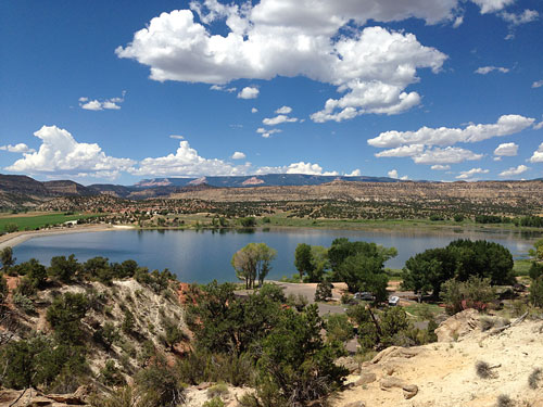
with our old dog Gordie. We arrived in Escalante in
the early afternoon in time to park the rig in a shady spot at
Escalante
Petrified Forest State Park near the shore of the Wide Hollow
Reservoir
(fishing and swimming OK)—our home for the next three nights.
ESCALANTE
(UTAH)
•Hiking
in Escalante State Park
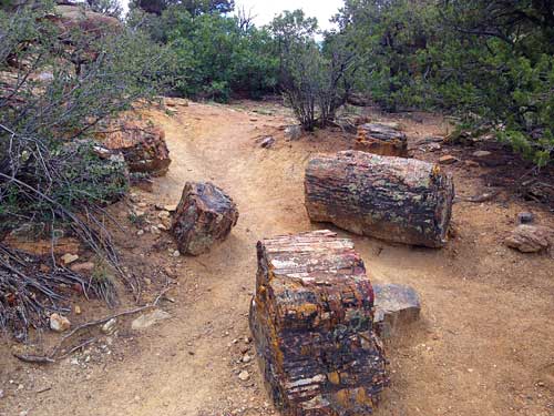
In the hills behind the campground are two adjoining
trails, one an extension of the other: the Petrified Forest Trail and
the Trail of Sleeping Rainbows. The first is a one-mile self-guided
loop that offers a few glimpses of the area’s petrified wood; the
second adds about another mile where the examples of petrified wood
rival the specimens found in Arizona’s Petrified Forest National Park.
(See phots below of a sampling of what we found.)
Later in the day we discovered there are geocaches in that area so we
returned in the early evening to grab a couple of geocaches in the
park.
•Hell’s
Backbone Scenic Backway
This 44-mile gravel road heads north up Pine Creek
Road out of Escalante, through a thickly wooded area to the Posey Lake
turnoff (a fairly popular fishing hole) and skirts the Box-Death Hollow
Wilderness area to the rugged Sand Creek crossing and down into the
ranching area leading into Boulder. The Hell’s
Backbone Bridge across
Sand Creek is an engineering marvel completed by the CCC in the early
1930s. The last time we came through here, we collected some pretty
good blood jasper specimens along the side of the road between the
bridge and highway 12. It’s an easy drive, though with the exception of
the bridge crossing, we didn’t find the trip time well spent. Too many
trees blocked most of the view, and there were no viewpoints until we
reached the bridge.
[On
our return to Escalante, we stopped in town in
search of air for a tire on our Rav4, a recurring problem since before
we left home. The Phillips 66 station had a source of free air, but
Doug in the tire shop suggested that the persistent slow leak could be
a sign of a more serious problem. He’d take a look and probably fix it
within 20 minutes if we wanted to hang out in town. With a pretty good
thrift store within an easy walk, we told Doug to go ahead. A half hour
later, Doug showed me the remaining inch or so of a 12 penny nail he
found attached to the inside of the tire. He patched it up and filled
the tire with air that has stayed in even after our return. That was
$25 well spent. Thanks, Doug!]
•Hole-in-the-Rock
Road
On the east side of Escalante is
the attractive and
informative Hole-in-the-Rock
Heritage Center that has displays and
photos pertaining to the San Juan Mission group, recounting their
remarkable trek, and the road they took that begins just a few miles
outside of town. The volunteers we met were informative and encouraged
us make the drive. However, we found the best source of information
about the road and what we might find along the way was Tracy Hassett,
a gifted photographer we met at his Gallery Escalante. He offered us
copies of very detailed maps he drew of the road and the sights along
the way: slot canyons, dinosaur tracks, arches, Dance Hall Rock, and
the Devil’s Garden (where the only rest room and picnic area are to be
found along the 57 miles of dirt road). His maps also offered specific
warnings about road hazards that can be found. However, he reassured us
we could easily make the drive; the last seven miles might be best
driven with a 4-wheel drive, high clearance vehicle. We’ll remember
that
the next time we come.
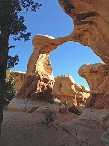
Because of some self-imposed time constraints, we
drove only as far as the Devil’s
Garden, a scenic area of sandstone
hoodoos that are fairly common throughout Utah’s southeast corner
(Goblin Valley State Park was designed to protect a large area of
hoodoos in the San Rafael Swell north of Hanksville). We spent a
leisurely hour or so wandering through the rocks enjoying the shifting
light and shadows created by the odd and fascinating formations. It was
another chance for the dogs to run freely since we were the only people
there. We wish we had not spent so much of the previous day on the
Hell’s Backbone Road.
KANAB (UTAH)
The remainder of State Route 12 passes through
fairly unpopulated areas scrub trees, sandstone cliffs, and dry creeks
until we came to the three small ranching towns of Henrieville (where you can turn off
to the very popular Kodachrome State Park and Cottonwood Canyon Scenic
Backway); Cannonville (about
the same size as Henrieville [pop. 200] but with camping facilities, a
grocery, and a paved access road to Kodachrome SP and Cottonwood
Canyon); and Tropic (on the
eastern edge of Bryce Canyon NP). A few more miles are the entrance to
Bryce and the eastern end of the very scenic Red Canyon where SR 12
ends at the junction with US 89.
A hour south on US 89 we passed through the very
productive ranching area of “Long Valley” and the towns of Oderville,
Mount Carmel Junction (where you turn to east entrance to Zion National
Park) near the summer home and museum dedicated to western artist
Maynard
Dixon, and finally to Kanab, home of Best Friends
Animal
Society and the location of the annual Western Legends Roundup
which we
were able to attend this year.
•Best Friends Animal Sanctuary
Most of you know we are strong supporters of Best
Friends, the largest no-kill facility for sick/abandoned/injured
animals in the country (maybe even the world). There are, at any one
time, about 1700 dogs, cats, bunnies, horses, mules, pigs, birds who
are being cared for: surgery and/or medication as needed,
socialization, and rehab, all to prepare them for adoption. If
necessary, some will live at Best Friends with the assurance of
lifetime care and safety. This is a non-profit organization we believe
to be worthy of our support of money and volunteer time. This year we
both chose to work at “Dogtown,” feeding and walking dogs each day and
cleaning pens and trails. Judy always works with the dogs; Hughes has
worked with horses, pigs, and birds as well as dogs in the past. People
we know who have volunteered there have found their time is well spent
and very rewarding.
•The
16th Annual Western Legends Roundup
For nearly 80 years, Kanab has played host to
Hollywood on location. The first movie made in Kanab was a Tom Mix
oater “Deadwood Coach” filmed in 1924, and was followed by 110 others
up to 2001. At least 15 TV series (including “Gunsmoke,” “The Lone
Ranger,” and “Daniel Boone,” to name just a few) were filmed entirely
or in part in the Kanab area. John Wayne, Tex Ritter, Barbara Stanwyck,
Ava Gardner, Charlton Heston, Sidney Poitier, and Clint Eastwood are
among the scores of actors who worked in the Kanab area, many staying
at the Parry Lodge, which was
there at the beginning of the arrival of
the film companies. The Roundup is an event that honors the film making
legacy of what has become know as “Little Hollywood.” There are 90
plaques along the sidewalks in town honoring most of the stars featured
in Kanab made films.
The three-day event brings many of the stars to town
for the celebration. The Roundup also pays tribute to the area’s
western
and cowboy life—and makes a three-day spike in the local economy:
motels and restaurants fill. The thousands of visitors can enjoy
demonstrations of blacksmithing and quick-draw shooting, old time farm
machinery and Model Ts, buckboards and Conestoga wagons, plus non-stop
western/cowboy music and storytelling throughout the three days.
Western movies made in the Kanab area were shown free of charge
throughout the day, including “The Life and Times of Grizzly Adams”
(with Dan Haggerty in attendance), “Buffalo Bill” (starring Joel McCrea
and Maureen O’Hara), and “Duel at
Diablo” (with James Garner and Sidney Poitier). Evening concerts this
year featured country music singer Lynn Anderson, cowboy poet Waddie
Mitchell, and cowboy music icons, the Sons of the Pioneers.
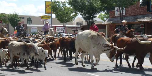
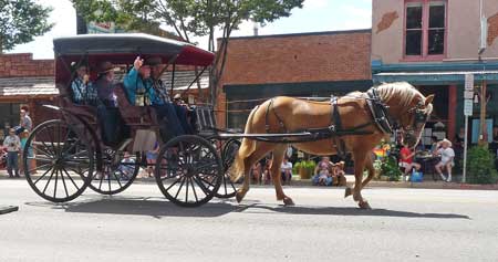
The highlight for many folks is always the parade at
high noon on Saturday when a fair sized herd of longhorn cattle leads
the non-motorized parade of horse drawn wagons down Kanab’s main street
(US 89). Seeing a herd of longhorns walking close to you helps a person
to realize what courage it takes to herd these huge and sometimes
cantankerous animals over trails for days on end. They are imposing
beasts not to be messed with. We were on high alert as they passed by
our spot on the curb, and kept the dogs tightly leashed and distracted
until they passed. Following the longhorns were dozens of wagons,
buckboards, and family groups on horseback, reminders of days gone by
and the ranching and pioneer heritage of the area.
When we were not working at Bests Friends or
checking out the displays, the movies, the entertainers and craft
booths on the streets in town, at the Round, we spent much of our time
searching out geocaches (we found about a dozen), walking our own dogs,
and paying our annual visit to the Kanab thrift store (slim pickings
this year). Judy rode her bike to Arizona (7 miles south is the Arizona
town of Fredonia) and together we rode east along US 89 almost to
Johnson Canyon in the late afternoon the day before we left.
COMING HOME
After a little over two weeks we had finished what
we came for, saw all the places we had planned to see plus some others
we hadn’t counted on, and we knew it was time to head for home. It’s
about 950 miles from Kanab to Nederland if we go by interstate. So we
figured if we could make good time the first day, the trip might take
only two days. With that in mind, we unplugged everything and pulled
out before 9:00 a.m. Our first stop was in Panguich, where we fueled up
with the cheapest diesel we found anywhere on the trip, then drove
through Circleville (home of Robert Leroy Parker, who later changed his
name to Butch Cassidy) and Marysville (a few miles south of Big Rock
Candy Mountain), and got on to I-15. We drove north to I-70 east and
drove as far as Fruita (Colorado) where we spent a comfortable night at
James M Robb Colorado River State Park. (There are five sections to
the
park, spread between Fruita and Island Acres, 26 miles east; the Fruita
section is one of two where full camping services are provided.)
We left early in the morning and drove hard through
some wet weather (rain and a fair amount of hail near Black Hawk and
Central City) and got home with enough light left in the day to get the
house opened up, turn on the hot water heater, unload the RV, and
collapse in the friendly comfort of our own bed for the first time in a
while.
As usual, in spite of all the terrific experiences
we had, we (Bella and Lucy included) were glad to be home. We counted
ourselves lucky that we had no issues with the RV (which we had not
used in nearly two years), or with the Rav4 (the nail in the tire
notwithstanding.) We didn’t break anything, no one got sick or injured,
and we returned with hundreds of photos and great memories.
This is at least our third road trip to Utah, and
though there are lots of other places we haven’t visited, we’re pretty
sure we’ll go back to Utah. It’s a state of great contrasts, beautiful
scenery, and fascinating history. If you haven’t been to Utah, you have
missed many wonderful sights and experiences. Thankfully for us, it’s
right next door to Colorado and begins less than a day’s drive. If you
have visited the state, let us know where you went and how you liked it.
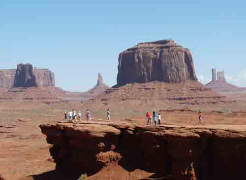
One last look at Monument Valley…